Epic Alternatives to the Half Dome Hike
Couldn't get a permit for Half Dome? Time to cancel your Yosemite trip, load up on whiskey and ammo, and launch the revolution, after which the scalpers will be the first ones up against the wall.
Or possibly, just time to pick a different hike.
There are, in fact, several astonishing not-Half-Dome day hikes in Yosemite that involve high mileage, punishing climbs, nowhere-else-in-the-world scenery, and (in some cases) exciting personal danger, but that do not require any permits at all. These, for instance:
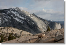
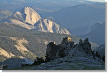
Clouds Rest · 14.5 miles (23.3 km) round trip · 1,775 feet (540 meters) elevation gain · 9,926 feet (3,025 meters) peak elevation
You get arguably superior views from the summit, where you'll be looking down at Half Dome from a thousand feet higher. And though there's no cable ascent, you'll still get your share of I-could-die-at-any-moment thrills as you negotiate the knife-edge ridge that leads along the summit to the modestly wider plateau at trail's end. You'll have a 360-degree vista of the park, including back to the trailhead at Tenaya Lake, which looks an impossibly long way distant from here.
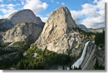
Four-Mile + Panorama Trails · 13.2 miles (21.2 km) round trip · approx. 4,000 feet (1,220 meters) elevation gain · 7,200 feet (2,200 meters) peak elevation
This combines two spectacular valley-to-rim hikes into a single challenging day. The major highlights are, on the Four-Mile Trail, a series of unmatched views of Yosemite Falls, and on the Panorama Trail, Nevada and Vernal Falls. But this hike also includes several other highlights that are worthy destinations all by themselves, including Panorama Point and the views of Illilouette Falls and Sentinel Rock. The two trails merge at Glacier Point on the valley rim, but the valley floor trailheads are about three miles apart, so if you elect to walk between them instead of taking the shuttle, you can stretch this into a 16-mile day.
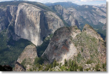
The Pohono Trail · 13 miles (21 km) one way · 3,700 feet (1,130 meters) elevation gain · 8,100 feet (2,470 meters) peak elevation
This hike takes you along the valley rim from one end of Yosemite Valley to the other, with Glacier Point and the Tunnel View at the endpoints and a variety of scenic high points, including Sentinel Dome and Taft, Dewey, Stanford, Crocker, and Inspiration Points, in between. Transportation for the one-way route can be tricky to arrange, so if you're really looking for an epic Half Dome replacement, make this a 26-mile round-trip marathon.
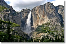
Upper Yosemite Falls & Yosemite Point · 9.4 miles (15 km) round trip · 3,000 feet (900 meters) elevation gain · 6,936 feet (2,114 meters) peak elevation
It's a switchback-laden grind from valley floor to rim with Yosemite's most magnificent waterfall to keep you company, and it comes with bonus views across the valley that you can't get from on top of Half Dome - the view of Half Dome, to name just one. Palm sweat will abound as you edge your way along the cliff to the top-o'-the-fall overlook. Listed mileage is from the Lower Yosemite Falls shuttle stop; you can lengthen the hike by walking instead of riding to the trailhead.
Half Dome Alternatives - Junior Division
Mount Hoffmann · 6 miles (9.5 km) round trip · 2,000 feet (600 meters) elevation gain · 10,845 feet (3,305 meters) peak elevation
It lacks elite-level distance, but the starting elevation would put you roughly in the middle of Half Dome's cable route, and you'll end up looking down on the dome from 2,000 feet higher. The steep ascent up the lower face of the mountain includes lots of slippery decomposed granite without the benefit of cables to keep you from sliding back down again. Acrophobics who reach the summit should avoid peeking over the north edge. Scenery bonus: the trail includes a pass along the south shore of picturesque May Lake.