May Lake & Mt. Hoffmann
Distance: 2.5 miles (4 km) round trip to May Lake; 6 miles (9.6 km) round trip if you climb Mt. Hoffmann as well
Elevation at trailhead: 8,710 feet (2,655 meters)
May Lake Elevation: 9,270 feet (2,825 meters)
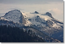
Mt. Hoffmann Elevation: 10,845 feet (3,305 meters)
Elevation Gain: 500 feet (150 meters) to May Lake; 2,000 feet (600 meters) to Mt. Hoffmann
Hiking Time: 1.5 - 4 hours
Why hike to May Lake? To see the only lake that, it can be said with some certainty, got a geologist some action. Charles Hoffmann, a member of the 1863-67 Whitney Geological Survey, named the lake after Lucy Mayotta Browne. In what was surely a related matter, Browne married Hoffmann in 1870. And is it just a coincidence that May Lake nestles in the lap of 10,845-foot Mt. Hoffmann? Not likely. Mr. Hoffmann appears to have been a man with a direct and pointed imagination.
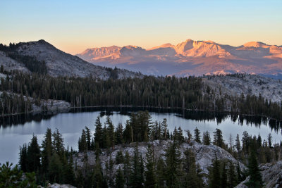
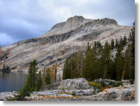
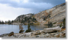
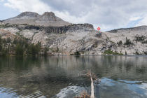
Scenery Factor: Like so many of Yosemite's high lakes, May Lake rests at the base of striking granite cliffs (Mt. Hoffmann, in this case), giving it a memorably picturesque backdrop. Unlike other lakes, though, May Lake's low side gives way not to forest, but to a drop off that looks over the Tioga Road area all the way to Clouds Rest and Tenaya Lake, a bonus that makes this one of Yosemite's most scenic lake hikes.
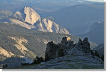
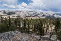
Still, though May Lake is pretty, it's Mount Hoffmann that makes this a four-star excursion. You don't get many chances to look down on both Clouds Rest and Half Dome without being a Horizon Air customer, and the views of the northern wilderness are nearly as compelling. The Mt. Hoffmann trail also includes some bonus views looking back to May Lake.
Virtual Yosemite has a few striking panoramas of the May Lake area, and Google Street View hosts several more. Highlights include an ice- and snow-filled view across the lake in June, a view of Mt. Hoffmann from the south shore, a view looking down on both May and Tenaya Lakes, a view looking down on Clouds Rest and Half Dome from near the Mt. Hoffmann summit, and a wide-ranging view from the summit.
Best Time to Visit: Whenever the Tioga Pass Road is open - typically June through October; see the Road Conditions page for the road's historical opening and closing dates
Difficulty: It's a short hike to May Lake, but it starts at a high elevation and climbs steadily, if not steeply, to the lake. It rates a 5 out of 10, excluding Mt. Hoffmann, which adds a couple notches to the difficulty rating.
Crowd Factor: You won't be alone here, since it's a fairly short hike and the May Lake High Sierra camp sits along the eastern shore. But it's not nearly as crowded as it would be if it were, like Mirror Lake, right next to Yosemite Valley.
Parking: Lot at the trailhead
Food Storage Lockers: In the trailhead parking area
Nearest Bathrooms: Pit toilets at the trailhead. There's also a flush toilet at the lake, thanks to the High Sierra Camp's presence here. It closes when the camp does. It doesn't have a sink, but there's a water outlet nearby that apparently draws directly from the lake.
Nearest Snacks: At the far end of Tuolumne Meadows, 13 miles (21 km) east
Getting There: From Yosemite Valley, take highway 120 ten miles (16.8 km) to the Crane Flat turnoff onto Tioga Road, then take Tioga Road 28 miles (44.8 km) east to the May Lake turnoff. From Yosemite's east entrance at Tioga Pass, take the Tioga Road west 20 miles (32 km) to the turnoff. From the turnoff, it's 1.8 miles (2.9 km) to the trailhead parking lot. Here's a Google Street View panorama of the turnoff.
Trail Notes & Hazards: The trail up Mt. Hoffmann is steep and rocky, and some of the steepest parts are covered with decomposed granite, one of the most insidiously slippery substances nature has devised in its campaign to add slapstick to the world. Between this and oxygen's inexplicable fear of heights, plan on a slow pace going up.
Bonus Spelling Tip: If you've got an N you need to tuck away in a witness protection program, stick it at the end of Hoffmann. I stared at this word for years on maps, signs, web pages, etc., before I noticed there was a second n at the back of it. Once I finally spotted it, I knew it couldn't be spelled Hoffmann on all those sources I'd been reading, so I went back and checked them and... there it was. On all of them. Judging from, among other things, the emails I get, I'm not the only one with Hoffmann blindness. But now you know.
Already done this hike? Add a Review.
May Lake Photos
May Lake Panoramas
From Virtual Yosemite
If you like May Lake, check out:
A gorgeous lake right around the corner
More hikes in the May Lake area
More far-ranging high-country views