The Merced National Wildlife Refuge
Hike Distance: Meadowlark Trail 1.5 miles (2.4 km) loop;
Kestrel Trail 0.5 miles (0.8 km) loop;
Bittern Marsh Trail 0.5 miles (0.8 km) loop
Trailhead Elevation: 100 feet (30 meters)
Elevation Gain: none
Distance from Yosemite: 83 miles (133 km); 15 miles (24 km) southwest of Merced
Admission: Free
Hours: Half hour before sunrise until half hour after sunset daily
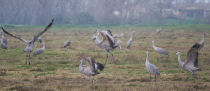
Why visit the Merced National Wildlife Refuge? It's Hitchcock's The Birds brought to life, except that the 60,000 geese, 15,000 sandhill cranes, 25,000 Tri-colored Blackbird pairs, and 200 other bird species haven't figured out that they outnumber you. Yet.
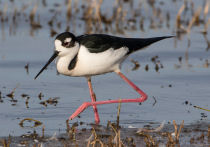
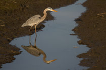
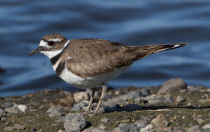
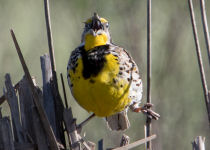
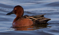
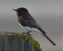
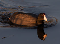
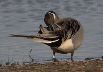
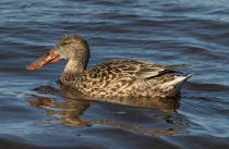
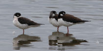
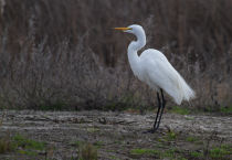
Scenery Summary: It's all about the birds here, and the numbers present in the winter are staggering - 15,000 cranes, 60,000 geese, 50,000 tri-colored blackbirds, and more than 200 species overall, from shy smaller birds like Virginia Rails to assorted large waterfowl (herons and egrets among the showiest of them) to raptors including owls, hawks, and eagles. Even if you don't care about birds, you'll enjoy watching Lesser Sandhill Cranes flapping about in the execution of their eccentric mating rituals - though they're certainly no weirder than a fraternity social - or thousands of geese lifting off at once in response to an eagle browsing overhead. Dedicated birders used to waiting hours for a species to appear may experience a kind of sugar overload at the embarrassment of riches here.
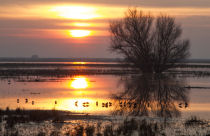
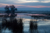
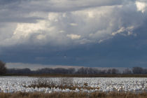
Birds aside - and there are birds on every side - you can also experience pretty sunsets gazing across the water from the southeast corner of the driving loop, and it’s interesting just to see a miniature slice of what the Central Valley was like before the arrival of humans, back when it was just trees and grass and marshes and the occasional information kiosk or viewing platform.
Best Time to Visit: December through February, when the bird population is highest. The refuge's official website has a month-by-month calendar of who's coming and going. On winter mornings the Central Valley's infamous tule fogs can reduce visibility but also provide handy depth-of-field reduction for photographers, and winter sunsets are memorable for the sheer cacophany when thousands of geese take off and wheel about before flying away to their overnight roosts.
Is It Worth the Drive? It's a relatively long ways from Yosemite - roughly an hour and a half from the 140 entrance. You can get there almost as fast from some parts of the bay area. But if you're driving to Yosemite in the winter via Merced and Highway 140 - the most likely route, since it's also the lowest-elevation one - then it's only a 15-mile detour from Merced, and definitely worth stopping.
Crowd Factor: Not bad. There will usually be other people there, with the main viewing platform the single place most likely to be occupied, but otherwise visitors will largely be spread out around the 5-mile driving loop. I rarely encounter people on the hiking trails.
Difficulty: Easy. The area is flat for miles around; the trails, besides being short, are smooth and wide; and the best birdwatching (the 5-mile driving tour) requires no walking at all.
Parking: Main lot near the entrance holds 20 or so cars; another near the southeast end of the refuge can accomodate as many more. Remember that you're parking in the vicinity of thousands of birds, and if you're driving a convertible, put the top up.
Nearest Bathrooms: Pit toilets at the visitor center, which consists of a parking area, a couple information signs, a picnic table, a viewing platform, and the aforementioned outhouse. Bathrooms with plumbing in Merced, 15 miles (24 km) away.
Nearest Snacks: Options abound in Merced, 15 miles (24 km) to the northeast
Getting There: If you're approaching from Yosemite on Highway 140, stay on it until it passes under the 99 freeway in Merced, at which point it veers right and joins 16th Street going northwest. (If you're on 99 south, take the Yosemite exit in Merced and turn right when you leave the offramp to join the 140-into-16th merger.) Stay on 16th for half a dozen blocks or so until you reach Highway 59, known as Martin Luther King Jr. Way in Merced. (It's between I and K streets.) Turn left on 59 and go south 8 miles (just under 13 km) to Sandy Mush Road. Turn right on Sandy Mush Road (there's a turn-here-for-the-Merced-Wildlife-Refuge sign at the intersection) and drive west 7.3 miles (11.7 km) to reach the refuge. See the driving map for more details.
Trail Notes & Hazards: The sightseeing routes here consist of three short hiking trails and a 5-mile (8-km) driving loop (see the trail map). And though this is an unhappy confession from a hiking-oriented website, the driving loop provides better birdwatching. Birds will scatter from a considerable distance when you’re on foot, even if you’ve showered and brushed your teeth, but on the whole seem only mildly concerned by cars in their midst. The ones next to the road will sort of nonchalantly sidle away as you drive past, but they're much chummier than the birds on the hiking trails. I have, however, generally seen more raptors on the hiking trails than on the driving loop.
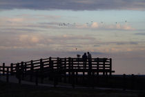
The refuge includes two viewing platforms, one near the main entrance at the northwest end and one in prime sunset-viewing territory at the southeast end. The northwest platform can pay off if you're still and patient; I’ve seen species like Sora and Virginia Rail - the latter a notoriously bashful bird - edge out of the bushes just a few dozen feet away.
Binoculars or a telephoto lens are highly useful here. And save your car wash tokens for after visiting the refuge.
Merced NWR Forecast
Loading Forecast...