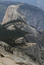
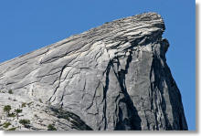
Half Dome: Your guide to Yosemite's most demanding day hike
FAQ · Trail Map · Satellite View · Photos · Video · Reviews
Hike Distance: 14.2 miles (22.7 km) round trip via Mist Trail
16.5 miles (26.5 km) round trip via John Muir Trail
20 miles (32 km) round trip via Glacier Point
23 miles (37 km) round trip via
Tenaya Lake
7 miles (11 km) round trip from Little Yosemite Valley campground
Half Dome Elevation: 8,846 feet (2,696 meters)
Total Elevation Gain: 4,800 feet (1,600 meters) from Yosemite Valley
Hiking Time: 10 - 14 hours
Why climb the trail to Half Dome? Half Dome is the ultimate Yosemite day hike - the one you can't die without doing, and the one you're most likely to die while doing.
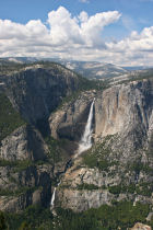
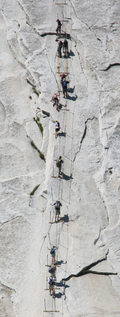
It's got 900 feet (300 meters) worth of spectacular waterfalls at the bottom if you take the Mist Trail route; bigger-than-life panoramic vistas at the top; and a knee-knocking, hand-clamming cable ascent that will test your courage, your strength, and the tread on your shoes.
Current Status: The cable route is open for the summer of 2026. It typically opens before Memorial Day weekend in May and closes after Columbus Day weekend in October, though those dates can vary depending on weather and snowpack conditions. See the NPS website's current conditions page for status updates.
Permit Alert: You'll need a permit to access the cable section of the trail. Most permits are awarded through a lottery that takes place at the end of March, with additional lotteries of 50 or so permits per day taking place throughout the summer two days in advance - more details below.
Crowd Factor: High - so high, in fact, that the park service has instituted a permit system for the cable route, a perennial source of bottlenecks. It appears that this has shifted the bottleneck from the cables to the permit-reservation system; in 2011 the permits generally sold out within an hour of becoming available, and in 2012 the park service switched to a lottery system, which remains in place. While getting a permit can be a challenge, the permit system has definitely reduced crowding, and the days of 45-minute waits to get onto the cables seem to be over.
If you don't mind lugging a big pack up the Mist Trail, you can arrive before the day hikers by spending the night before in Little Yosemite Valley and getting an early start the next morning. (You'll need a wilderness permit to do this.)
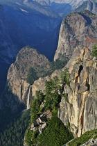
Scenery Factor: Unsurpassed.
Sundry Half Dome Goodies
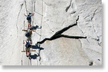
Difficulty: Extreme. It's long, steep at the beginning and end, and more dangerous than most Yosemite hikes. It's probably the most difficult of all Yosemite day hikes. On the traditional 1 to 10 scale, this one rates an 11.
Insanity Factor: 9 out of 10. Wait 'til you get to the cables, and you'll see.
Best Time to Visit: You can't climb Half Dome unless the cables are up, which is generally from late May or early June through Columbus Day weekend in October. The waterfalls will be better the earlier in the year you go. Avoid Half Dome on days when there are thunder clouds in the area - it's not worth the risk. Even rain without lightning will make the granite on the cable route dangerously slick, so it's best to skip stormy days altogether.
Unlike 2010, when the route was less crowded on weekends due to the new permit system, and every year before 2010, when the route was less crowded on weekdays, the new permit-required-every-day system (read more) means that no particular day of the week will likely be substantially less crowded, but permits are generally easier to get for weekdays, and much easier to get for September and October (see the park service's charts showing historical permit applications and success levels). The park service only issues around 350 permits per day for the cable section (225 for day hikers via the March lottery, 75 for backpackers, and another 50 or so given out via lottery two days in advance), and not all the permit holders show up, so there will usually be less than 350 climbers.
Bathrooms: At Happy Isles (including plumbing), just across the river from the trailhead; at the bridge below Vernal Fall (also with plumbing); near the Emerald Pool above Vernal Fall (outhouse style); above Nevada Fall (outhouse); and at Little Yosemite Valley campground (requires a short detour from the trail).
Nearest Snacks: At Curry Village, which is three quarters of a mile (1.2 km) from the trailhead. The restaurants and market there won't be open when you start your hike at 6 a.m., though.
The last potable water is just across the bridge below Vernal Fall, 0.8 miles (1.2 km) up the trail.
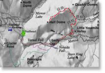
Driving Directions: The trailhead is at the east end of Yosemite Valley, to which almost all roads in Yosemite lead. From 140, just stay on the road until you're in Yosemite Valley; from the north (Big Oak Flat) entrance, do the same; from the Tioga Road, go west until it terminates at Big Oak Flat Road, then turn left and follow Big Oak Flat Road to the valley; from the south entrance, take highway 41 (which you're already on) all the way to the valley.
Once you've reached Yosemite Valley, keep an eye out for signs to Curry Village and head in their general direction. Once you've reached the Curry Village vicinity of the valley, you should start spotting signs for trailhead parking. Follow them to the trailhead lot or park at Curry Village.
If you're taking the Glacier Point route, take highway 41 to Glacier Point Road and then take Glacier Point Road to its eastern terminus at, appropriately enough, Glacier Point.
Parking: Your closest option is the trailhead parking lot, roughly halfway between Curry Village and the trailhead. It's the right turn in this Google Street View panorama. The trailhead lot has a few dozen bear-proof storage lockers in which you can store all the scented stuff you don't want to haul up the trail with you, though they tend to fill up early. If you drive out to the trailhead lot, you'll have to either park or turn around, as the road beyond is closed to private vehicles.
If the trailhead lot is full, you can park at Curry Village, which you'll find near the east end of Southside Drive. As you head east into Yosemite Valley, you'll find road signs pointing the way.
If you're taking the long route from Glacier Point, park in the Glacier Point parking lot and take the Panorama Trail, which will intersect with the main Half Dome route just above Nevada Fall.
For most Yosemite Valley hikes, you can park in any lot and catch a free shuttle bus to the trailhead. If you're planning a dawn start for Half Dome, though, as most day hikers do, that won't work, because the buses don't start running until 7 a.m.
Already done this hike? Add a Review.
Hiking Half Dome: The Official Park Service Video
Footage of the cable route starts at around the 5:40 mark, but there's lots else here, including video of Vernal & Nevada Falls, the subdome, and the top of Half Dome, plus hiking advice from the people who'll have to haul you back down the mountain if you injure yourself. If you're planning your first Half Dome hike, this will be ten minutes of your life well spent.
More Half Dome Questions That Pop Up a Lot
- How many people have died on Half Dome?
- Is the cable route open right now? When is it usually open?
- Can I climb/hike Half Dome when the cables are down?
- Which route should I take?
- Where should I stay the night before I climb Half Dome?
- What's Little Yosemite Valley? Do I need a wilderness permit or a reservation to stay there?
- Can I camp on Half Dome?
- Do I need a permit to hike the Half Dome trail?
- How do I get Half Dome permits?
- How much do Half Dome permits cost?
- Are Half Dome permits transferable?
- Where do I go (and when) to enter the lottery for Half Dome permits?
- How many permits and dates can I apply for?
- How many times can I enter the lottery?
- How can I increase my chances of winning the Half Dome permit lottery?
- I couldn't get a Half Dome permit. Now what?
- Where can I get water along the trail?
How many people have died on Half Dome?
There have been more than 20 deaths on Half Dome itself, and if you count the trail leading up to Half Dome, the number leaps to more than 60.
People have died on Half Dome from a variety of causes: falling off the cable route, heart attacks while climbing the cables, lightning strikes, failed base jumps, climbing accidents, and even a few suicides. The most recent death occurred in July of 2024, when a hiker slipped from the cables while attempting to descend during a storm. Hikers also slipped from the cable route in in September of 2019 and May of 2018. In 2011, two hikers had fatal accidents on Half Dome: one fell off the face of the dome on August 22nd, and another fell while descending the cable route on July 31st after a rainstorm had made the route even more slippery than usual. In June of 2009, a San Ramon Man fell while trying to descend the cables during stormy conditions. In June of 2007 a Japanese climber fell to his death while ascending the cables, and another hiker fell to her death the same year trying to climb the route when the cables were down. The cable route is extremely dangerous; please don't do it unless you're well prepared. These tips on surviving the cable ascent are a useful starting point.
Deaths on the trail to Half Dome, rather than on Half Dome itself, are usually above Nevada or Vernal Falls, and usually occur when someone wades into the the water above the falls or slips off rocks into the water and gets swept away. In many cases, their bodies have never been found.
For more information, read the macabre but remarkable Off the Wall: Death in Yosemite, which chronicles every unnatural death in the park from its inception until the book went to press in early 2007; and Shattered Air, an account of the lightning deaths on Half Dome on July 27, 1985.
Is the cable route open right now? When is it usually open?
The cable route is open for 2026. The cables typically go up in May the weekend before Memorial Day weekend and come down after Columbus Day weekend in October, though these dates can vary depending on weather conditions and, in the spring, how long it takes for the snow on the subdome and the cable route to melt. Check the NPS Current Conditions page for the latest status.
Can I climb/hike Half Dome when the cables are down?
There won't be a ranger at the base of the cable route to stop you from going. But it's a really bad idea. When the cables come down, they're not actually removed from the mountain. The poles that hold them up at waist level for handy gripping are removed from their sockets, and the cables lie flat (although "nearly vertical" would probably be more descriptive than "flat") against the side of Half Dome for the winter. The cable route is difficult and dangerous when the cables are up, and doubly so when they're down. A hiker died attempting to climb Half Dome with the cables down in the fall of 2006, and another fell and died in April of 2007. With the cables down, the Half Dome ascent becomes the province of climbers, not hikers.
Which route should I take?
The three main routes converge at the top of Nevada Fall, so unless you're coming from Tenaya Lake or the Little Yosemite Valley campground, it's really a question of which route you want to take for the first third or so of the hike.
The Mist Trail route is the shortest and most scenic, and deservedly the most popular. The Muir Trail route is about 1.5 miles (2.4 km) longer each way, but less steep, and might be a better choice if you've got balky knees. It might also be preferable if you're hiking at night during peak runoff season - getting soaked with spray is way more fun during the day, when you'll dry out quickly. The Muir Trail route starts from the same trailhead as the Mist Trail, departs from it almost a mile into the hike (just after you cross the bridge that gives you your first glimpse of Vernal Fall - the turnoff is well marked), and rejoins it again at the top of Nevada Fall.
The Glacier Point route has less climbing than the previous two routes, but, due to its length, is probably still more difficult. It also means you'll be ending your very long day with a couple miles of uphill switchbacks as you climb to Glacier Point from Illilouette Falls, a prospect you're likely to regret.
Hiking Half Dome from Tenaya Lake in one day isn't a realistic option unless you're in marathon-caliber condition, but hiking in from Tenaya Lake is a possibility if you're staying in the Little Yosemite Valley campground the night before you climb Half Dome. It's 11 miles (18 km) from Tenaya Lake to the Little Yosemite Valley campground.
Where should I stay the night before I climb Half Dome?
Last call at the Ahwahnee Bar is 11 p.m., so you'll need shelter someplace. Where depends on two factors: how many miles you're willing to hike on the day you climb Half Dome and how long a drive you'll endure to get to the Half Dome trailhead.
If you want to cut your mileage down on the day you climb Half Dome, spend the night in the Little Yosemite Valley campground, a mile beyond the top of Nevada Fall. This way you won't have to climb the Mist Trail the morning of your hike - a savings of about 4 miles (6.5 km) one way. You'll be a couple hours ahead of the midday hordes of Half Dome hikers, and you'll get to the cables before it gets too crowded.
However, this is a backpackers-only campground with no road access, which means that you'll need to pack all your camping gear up the Mist Trail the day before: tent, sleeping bags, food, cooking gear, framed Ansel Adams prints, manicure kit, etc. And unless you can stay two nights, you'll have to pack up and haul it all down the Mist Trail after climbing Half Dome. If you're out of shape, staying in Little Yosemite Valley Campground probably won't help you much unless you can convince someone else to carry your pack for you; the best reason to stay here is to beat the crowds up Half Dome.
If you're not a backpacker and you can't be trusted behind the wheel before 6 a.m., get reservations (well ahead of time, it should be emphasized) in Yosemite Valley. Anywhere in the valley will mean a short drive to the trailhead - less than 5 miles (8 km) in all cases. Staying in El Portal isn't bad, either; it'll give you a 15-20 minute drive. If you're a morning person (and by the way, no one wants to hear what a beautiful sunrise it was), you've got no worries. Anywhere in Yosemite except the eastern end of Tioga Road will get you to the valley in less than an hour, and you won't be hitting any traffic jams at the time you'll be driving. It's possible to depart from Oakhurst pre-dawn and be on the trail inside an hour and a half.
This all assumes that you're starting from the Yosemite Valley trailhead. If you're taking the longer route from Glacier Point, your closest overnight option (and the only one on Glacier Point Road) is the Bridalveil Creek Campground, 8 miles (13 km) from the trailhead.
What's Little Yosemite Valley? Do I need a wilderness permit or a reservation to stay there?
Little Yosemite Valley lies upstream from Nevada Fall, at an elevation of 6,100 feet (1,860 meters). The hike-in campground here is a little under 4 miles (6.5 km) from the trailhead in Yosemite Valley and about 3.5 miles (5.5 km) from the summit of Half Dome. It's the closest starting point to Half Dome, so if you're determined to beat the bottlenecks at the cables, spend the night here and get an early start the next morning, and you'll have a two or three hour head start over the crowds hiking up from the the Happy Isles trailhead in Yosemite Valley.
You do need a wilderness permit to camp in Little Yosemite Valley, but you don't need a campground reservation - if you've got the wilderness permit, you're allowed to camp here. Wilderness permits are free (sort of - more on this in the next paragraph), but, for this area, extremely popular, and doubly so since the institution of the Half Dome permit system. The park service allows 60 percent of the wilderness permits for any particular trailhead to be reserved up to six months in advance, and holds the other 40 percent back to give out to lucky hikers the day of travel or up to 24 hours in advance. The wilderness permits office in Yosemite Valley (next to the post office in Yosemite Village) opens at 7:30 a.m., and typically a line forms there well before the office opens. If you want one of the 40% of permits handed out at the last minute, try getting in line early in the morning the day before you want to head up to Little Yosemite Valley.
If you know well in advance when you're planning to climb Half Dome, you want to camp in Little Yosemite Valley, and you prefer to get your drama from actual outdoor adventures rather than from trying to make logistical arrangements, reserve your wilderness permit ahead of time. You can do this from the National Park Service website or by calling 209-372-0740. You can get permits for groups of up to 15 people. You'll have to pay a $5 flat fee plus $5 per person for the wilderness permits if your reservation is confimed, plus $10 per person for Half Dome permits.
The park service limits permits to 30 people per day from the Happy Isles/Yosemite Valley trailhead, 25 people per day from the Glacier Point trailhead, and 40 per day from the Tenaya/Sunrise Lakes area, including both reservable and first-come, first-servce permits. Given that some people camp multiple nights in Little Yosemite Valley and that the park service also issues permits for other trailheads that are part of multi-day swings through the Half Dome area, plan on sharing the campground with about a hundred other campers on any given night.
One more thing to keep in mind: Half Dome is probably Yosemite's most strenuous day hike, and although camping in Little Yosemite Valley allows you to spread it over multiple days, it also means you'll have to do all but the section from LYV to the top of Half Dome while packing a tent, sleeping bag, and other creature comforts on your back - it's about 4.5 miles (7 km) from Yosemite Valley to the Little Yosemite Valley campground, with more than 2,000 feet (600 meters) of climbing. So unless you've got a personal sherpa, this option isn't overwhelmingly easier than doing it all in one day. The primary advantage of overnighting in Little Yosemite Valley is being able to get to the cables before the crowds arrive.
Can I camp on Half Dome?
Nope. On your way up the trail you'll find this sign explaining why not.
Do I need a permit to hike the Half Dome trail?
Yes. Since 2012, permits have been required every day of the week. Without a permit, you can hike only as far as the base of the subdome, which is where a series of switchbacks begin about a quarter mile before the base of the cables (see this photo). Permits are awarded via lottery - see the next topic for more information.
In addition to a cable-route permit, you'll need a wilderness permit if you want to camp out somewhere along the trail instead of doing Half Dome as a day hike. See the Little Yosemite Valley FAQ just above for more on wilderness permits & where to get them. If you're getting a wilderness permit, you can get a Half Dome cables permit at the same time without having to make additional reservations.
How do I get Half Dome permits?
Half Dome permits are awarded via lottery. Entry for the main lottery (225 permits per day) takes place during March, and throughout the summer the park service also awards another 50 or so permits per day two days in advance, again by lottery. You can apply for these permits online or by calling 877-444-6777. The number of extra permits awarded will vary depending on their estimates of how busy the trail will be. Here's the park service's explanation of the extra permits:
Additional permits are available each day by lottery during the hiking season. These permits are available based on the estimated rate of under-use and cancellation of permits. The daily lotteries have an application period two days prior to the hiking date with a notification late that night. (So, to hike on Saturday, you would apply on Thursday and receive an email notification of results late on Thursday evening. Results are also available online, or by phone the next morning.) The application period is from midnight to 4 pm Pacific time.
How much do Half Dome permits cost?
Entering the main lottery costs $10 for online or phone applications (877-444-6777). You can request up to six permits per application. Lottery winners will have an additional fee of $10 per person. The lottery application fees are non-refundable, but you can get refunds for the $10/permit fees if you cancel more than two days before the hike date or if the cables aren't up on the day of your hike. The NPS website has the official details about the lottery process plus a page showing graphs of the number of permits requested for each day.
Are Half Dome permits transferable?
The permits for the trip leader and alternate cannot be transferred, though the trip leaders can bring along anyone they want for the remaining permits. This policy, instituted in 2012, is intended to prevent permit hoarding and scalping, which were reportedly widespread during 2011. When you enter the lottery, you have to enter somebody's name as the "trip leader", and you can optionally list an alternate trip leader as well. If neither the trip leader nor the alternate are present on the hike, none of the permits will be considered valid and your group won't be allowed past the permit-checking station at the base of the subdome.
Where do I go (and when) to enter the lottery for Half Dome permits?
For the main lottery, which accepts applications throughout the month of March, you can apply by phone at 877-444-6777 or online at the National Recreation Reservation Service for a $10 fee. For the two-days-ahead permits, apply sometime before 1 p.m. Pacific time two days before the day for which you want a permit (apply on Thursday if you want permits for Saturday, for example).
How many permits and dates can I apply for?
Up to six permits (i.e., permits for six hikers) per application, and for the main lottery, up to seven dates. Applicants are only awarded permits if the full number of requested permits is available for one of the requested dates, and though you're allowed to ask for multiple dates, you'll only be granted permits for one of them (and possibly none, obviously).
How many times can I enter the lottery?
For the main lottery, you can request up to seven dates in your application (you'll only be awarded permits for one of them), but you're only allowed to enter the lottery once. If you enter more than once, all your applications will be discarded. The park service's permit information page doesn't currently prohibit parties from trying to increase their odds by having each member of the party enter the lottery, though, and presumably applying for the March lottery wouldn't prohibit you from entering the various two-days-ahead lotteries as well.
How can I increase my chances of winning the Half Dome permit lottery?
Ask for permits for the least popular days. The park service publishes charts showing the number of permits requested per day, and the trend is that Mondays through Thursdays and September/October will give you your best overall chances, with weekdays from late September into October having a near 100% success rate for first-choice requests. Saturdays are by far the most difficult days to get permits for.
I couldn't get a Half Dome permit. Now what?
Here are some options:
1) Enter the lottery for the 50 or so extra permits that the park service will be issuing two days before the hike. (For a Saturday hike, you can enter the lottery Thursday until 1 p.m., for instance, and the results will be available sometime Thursday night. More details here.) You'll need phone or, preferably, Internet access, which is available in Yosemite Valley in a handful of places. According to the park service's graphs, daily permit apps had 25% overall success rate in 2017 (32% on weekdays and 14% on weekends), with the chances of success going up substantially during September and October.
2) Backpack in and make it a two-or-more-day trip. If the Half Dome permits are gone, all the wilderness permit reservations will also be long gone, but the park service holds back some wilderness permits for first-come, first-serve requests starting at 11 a.m. the day before departure, and for a few routes, a wilderness permit entitles you to a Half Dome permit as well (you need to specify on your application that you also want a Half Dome Permit). These routes include Happy Isles to Little Yosemite Valley (12 first-come, first-serve permits per day), Glacier Point to Little Yosemite Valley (4 per day), Tuolumne Meadows to Sunrise Lakes (8 per day), and Tuolumne Meadows to Cathedral Lakes (10 per day). For the two starting from Tuolumne Meadows, your permit to stay in the Little Yosemite Valley campground will be for the second night out on the trail. Check the park service's wilderness permits, trailhead information, and Half Dome permits for backpackers pages for the official details.
These Half-Dome-included wilderness routes are, not coincidentally, the most popular, and it won't be easy to get a permit. For years, crowds camped overnight outside the wilderness permit offices to increase their chances of getting permits, but starting in 2011, the park service tried to discourage this behavior by waiting until 11 a.m. to start awarding permits.
3) Try one of these hikes instead. They're all long, challenging, and equally as scenic as Half Dome, but they don't require permits. Clouds Rest in particular has parallels to the Half Dome hike. From the summit you're actually looking down on Half Dome, some two miles away and a thousand feet below you, and you have to traverse a harrowing stretch along a narrow ridge with fatal dropoffs on either side to get to the viewing area at the end of the trail.
Where can I get water along the trail?
1) The drinking fountain at the Vernal Fall footbridge: It's a mile (1.5 km) into the hike. For the six miles beyond the footbridge, there's no potable water along the trail - not even at the Little Yosemite Valley campground, which technically isn't quite on the trail anyway.
2) The Merced River: If you carry a filtration system, you can get water from the Merced River in Little Yosemite Valley, which lies above Nevada Fall slightly more than halfway to Half Dome. It's illegal to abscond with any of the park's natural artifacts, such as rocks, pine cones, or giardia, so don't try to drink from the river without using a filtration system.