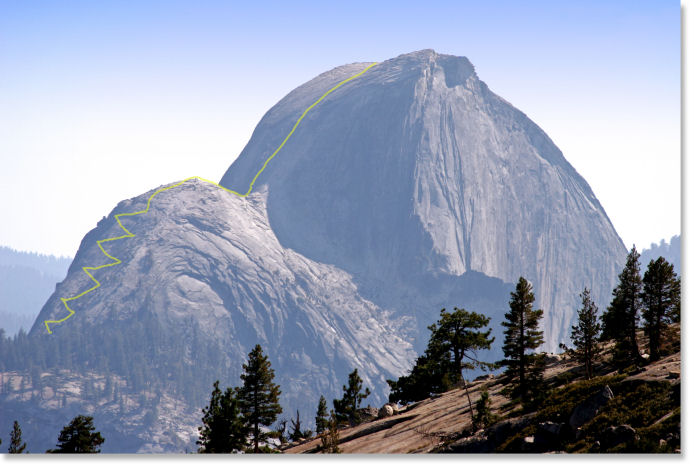
The Route up Half Dome: Part 2 (optional squiggle-free version)
You'll approach this final stretch of the Half Dome trail from the left (see part 1). Keep in mind that these trail squiggles are mere approximations; a ghastly fate would await the hiker who tried to follow them literally. The salient facts to take away from this rendering are these: you'll climb the first (eastern) hump, the subdome, which is almost as steep as as the cable section of Half Dome, via a challenging series of switchbacks, then descend to cross the narrow saddle (it's about 20 feet/6 meters wide), and finally shoot 400 feet (120 meters) straight up the cables to the top of the dome, which, despite appearances, is at least the size of a football field on top.
If you're climbing Half Dome when the cables are up (the only time when you should), you'll probably find a ranger posted somewhere in the vicinity of the bottom of the yellow line, and you won't be allowed past that point without a permit. It would be a shame to get turned back here, because once you climb above the trees, you'll get impressive views back towards the east to Clouds Rest and the high Sierras.
If you want to take in this view for yourself, you'll find it at Olmsted Point. Bring your binoculars; at Olmsted Point, Clouds Rest is the closeup star and Half Dome is several miles off. They weren't visible through the 300 mm telephoto lens used for this picture, but some of you probably own lenses powerful enough to see the cables from here.