The Mist Trail (Vernal and Nevada Falls)
Distance: 3 miles (4.8 km) round trip to Vernal Fall, 7 miles (11 km) round trip to Nevada Fall. If you walk from Curry Village instead of catching a shuttle bus to the trailhead, add an extra 1.5 miles (2.4 km) round trip.
Elevation at trailhead: 4,000 feet (1,200 meters)
Elevation Gain: 1,000 feet (300 meters) to top of Vernal Fall; 1,900 feet (580 meters) to top of Nevada Fall
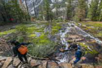
Summer Closures: The section of the Mist Trail from the junction with the John Muir Trail (just upstream from the Vernal Fall footbridge) to the top of Vernal Fall will be closed 7 AM - 3:30 PM Monday - Thursday from July through October of 2024. Hikers will still be able to reach the top of Vernal Fall by detouring via the Muir Trail. In addition, a section of the Muir Trail near the top of Nevada Fall is expected to be closed until late June due to rockfall. See the NPS current conditions page for the latest status.
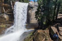
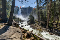
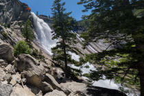
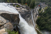
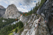
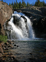
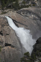
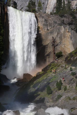
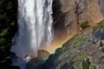
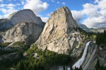
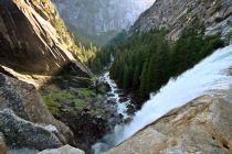
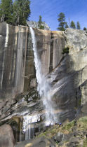
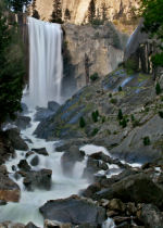
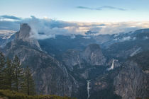
Why Hike the Mist Trail? This is Yosemite's signature hike. While many of Yosemite's trails are popular due to having a single spectacular destination, the Mist Trail has fabulous views scattered all along it, beginning at the bridge overlook, progressing to two unforgettable waterfalls that fall a combined total of more than 900 feet (270 meters), and ending with perhaps the most striking of all: the view of Nevada Fall, Liberty Cap, and the back of Half Dome from the Muir Trail return segment.
Best Time to Visit: During peak runoff, which is generally from April into June, though after particularly snowy winters this can extend well into July. See the Should I Hike the Mist Trail Today? page for examples of how the falls look at various states of water flow and for information on current flow levels.
Because the Mist Trail is such a popular hike, time of day matters as well. If you're hiking it during peak season, and especially during a peak season weekend, you'll get the best experience starting early in the morning or later in the afternoon (in the latter case, be sure to pack a flashlight). Hit the trail by 7 AM, assuming you possess the sort of superhuman getting-out-of-bed powers that this entails, and crowds won't be a factor for you until your return trip to the trailhead.
Hiking Time: 2 - 8 hours, depending on how far you go
Scenery Factor: Sublime. You can get covered-with-spray close to two of Yosemite's rock-star waterfalls, and the view looking back from the Muir Trail is just as remarkable as the trail up the falls.
Crowd Factor: Heavy to the top of Vernal Fall, especially when the water is high. The crowds thin out considerably if you continue to the top of Nevada Fall, although several trails intersect at the top of this fall, so you won't be alone there.
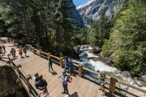
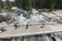
Difficulty: Medium, but bordering strenuous if you go all the way to the top of Nevada Fall. The stretches beside Vernal and Nevada Falls are both quite steep - in fact, the last few hundred meters up the Vernal Falls trail are stairs cut into the cliffside. If you need a gentler workout, you can just proceed as far as the bridge looking upstream to Vernal Fall without exerting yourself quite so much.
Parking: You can park just about anywhere in the eastern half of Yosemite Valley and catch a free shuttle bus to the trailhead near Happy Isles. The nearest parking, however, is at the trailhead parking lot, which is just east of Curry Village (Half Dome Village). If it's full, try Curry Village itself, where you can usually find a spot if you're willing to poke around in the back corners of the unpaved section of the lot.
Nearest Bathrooms: Park planners were apparently concerned about what subliminal messages our bladders would receive from the sight of all that flowing water, because the Mist Trail is Yosemite's toilet king. Besides the ones at Curry Village, you'll find them across the bridge at the first overlook, at the top of Vernal Fall, and at the top of Nevada Fall.
Nearest Snacks: Restaurants and a convenience store at Curry Village, 3/4 of a mile (1.2 km) west of the trailhead. During the summer you can get drinking water at the Vernal Fall footbridge, roughly a mile up the trail.
Getting There: In Yosemite Valley, follow the signs to Curry Village. From Curry Village, a good place to park, hike southeastish on Southside Drive until you reach the trailhead or catch a ride on one of the free shuttle buses. Alternately, you can check the trailhead parking lot, which is roughly half a mile past Curry Village and another half mile or so short of the trailhead itself. This lot tends to fill up early with people doing the Half Dome hike, though. Private vehicles aren't allowed on the road past the trailhead parking lot, so you can't drive all the way to the trailhead.
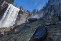
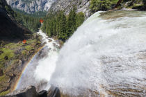
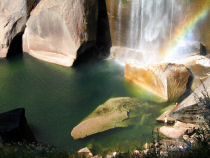
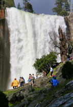
Hazards: It's illegal to remove any natural objects from a national park, but everyone who hikes the aptly named Mist Trail in the early season is a scofflaw: it's impossible to hike to the top of Vernal Fall in the spring without taking a little piece of the fall with you. You will get wet. Very wet. Taking-a-shower wet. Jumping-in-the-ocean wet. Bring rain gear.
For related reasons, the stone steps carved into the canyon wall beside Vernal Fall can be slippery, so tread carefully.
Readers of the morbid yet mesmerizing Off the Wall: Death in Yosemite will be aware of the surprising fact that more people die on the Mist Trail than almost anywhere else in Yosemite. It's not the waterfalls or the cliffs that are the culprits; it's the current. The river here apparently looks much less dangerous than it actually is. Typically, a hiker slips into the water and finds the current too strong to overcome, then gets swept to a regrettable death somewhere downstream. So please be careful when you're near the river.
Already done this hike? Add a review.
Mist Trail Photos

Mist Trail Panoramas
From Virtual Yosemite