Carlon Falls
Hike Distance: 3.8 miles (6 km) round trip
Trailhead Elevation: 4,315 feet (1,315 meters)
Elevation Gain: 200 feet (60 meters)
Hiking Time: 1 - 2 hours
Why hike to Carlon Falls? It's Yosemite on the cheap - you can visit this waterfall without going through a manned entrance gate. The falls are inside the park, but the trailhead isn't.
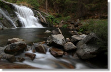
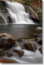
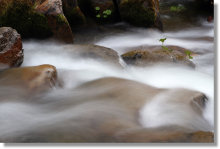
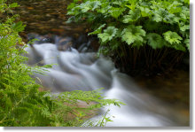
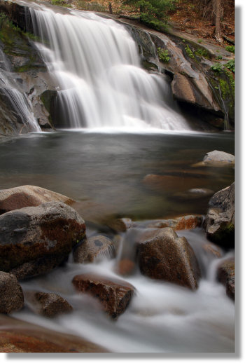
Scenery Summary: Carlon is a personal-sized waterfall, twenty or thirty feet high and roughly as wide (the width varies over the course of the year), with a pool at its base and a series of small cascades downstream. The trail follows the South Fork of the Tuolumne River, and if you're there early enough in the year, guides you past a variety of wildflowers. As the summer progresses, ferns and Indian Rhubarb along the river add to the hike's bucolic nature. It doesn't take too much license to posit that Carlon Falls and the Lewis Creek trail to Red Rock Falls have a separated-at-birth thing going.
Google Street View has a few panoramas of the falls, one taken during spring runoff when swimming below the falls would be risky - though that would cut down on the number of people you'll see there - and a couple more taken farther downstream and showing some of the cascades along with the falls, one taken in spring and another taken in late summer during a dry year.
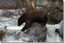
Crowd Factor: It becomes a popular swimming hole once the water flow has subsided to safe levels, so visit early or late on a weekday for the best chance of solitude. Fishermen are a common sight along the river near the trailhead; they tell me they're catching rainbow and brook trout. It would be unusual, but not unprecedented, to have your reveries interrupted by a bear. Fish may be seen jumping out of the water, but they usually go right back in again.
Difficulty: John Muir couldn't do this hike. We must consider, however, that he is dead. For anyone else shy of Steven Hawking, this trail shouldn't be a problem. There's a short, steep ascent near the end, but for the most part, it's an easy hike along the South Fork of the Tuolumne River. The trail is smooth and only occasionally dimpled by roots & rocks.
Best Time to Visit: High water adds to the buzz at big waterfalls like Yosemite and Bridalveil, but it can overwhelm more modest falls like Carlon where serenity, not spectacle, is the attraction. This hike is generally best once the spring runoff is spent and the rapids have given way to pools - say late May to September, with some variance depending on how much snow pack there was the previous winter.
Parking: The pullout at the trailhead holds four or five cars, and the parking lot at the picnic area across the bridge holds eight more.
Nearest Bathrooms: Pit toilet across the bridge at the picnic area. Toilets with plumbing at the Big Oak Flat park entrance (2 miles/3 km away) and the Evergreen Lodge (5.5 miles/9 km farther up the road). Also, you will be in the woods.
Nearest Snacks: A few vending machines stand next to the parking lot at the Big Oak Flat Yosemite entrance, two miles away; the selection is limited but you can't beat the hours. One wonders how they keep the bears out of them. The Evergreen Lodge (5.5 miles/9 km farther along Evergreen Road) has a restaurant, saloon, and small general store.
Getting There: Take Evergreen Road (the road to Hetch Hetchy), which begins a mile outside the park's Big Oak Flat (Highway 120/northwest) entrance. A mile along the road will be a bridge over the Tuolumne River. There'll be a parking lot and outhouse on your right next to the near side of the bridge. The trailhead, also on the right, is on the far side of the bridge. A pullout there has room for a handful of cars. Here's a Google Street View panorama of the trailhead parking area.
Trail Notes & Hazards: The trail begins in Stanislaus National Forest but enters the park a hundred meters or so along. You'll know when you reach Yosemite because you have to squeeze through a narrow V-shaped gate designed to thwart motorcycles and pantomime horses.
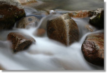
A couple small streams cross the trail; both should be dry by late summer. As always, where there's water, there can be mosquitoes. If you're planning to go into the water, please wait until after the spring runoff. Don't weigh just the water depth, temperature, and current when you're calculating the danger level - remember that river beds are often slippery as well.
Already been to Carlon Falls? Add a Review.