Lewis Creek (Red Rock and Corlieu Falls)
Hike Distance: 0.5 miles (0.8 km) round trip to Corlieu Falls; 3 miles (4.8 km) round trip to Red Rock Falls.
Distance from Yosemite: 7 miles (11 km)
Trailhead Elevation: 4,000 feet (1,220 meters)
Elevation Gain: 300 feet (90 meters)
Hiking time: 1 - 2 hours (Red Rock Falls); 15 - 30 minutes (Corlieu Falls)
Bridge-Out Alert: The bridge near the start of the Red Rock Falls trail washed out over the winter. In its place is a temporary assemblage of branches and assorted jetsam with a rope guide that adventurous hikers can use to cross the creek.
Why hike the Lewis Creek trail? Not all of Yosemite's greatest sights are in ... well, Yosemite. Visit the waterfalls on this trail and you'll be wondering why the park's founders didn't draw the border another seven miles south to include them.
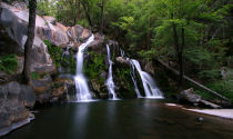
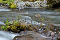
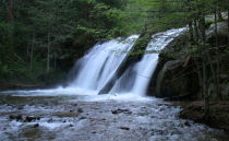
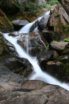
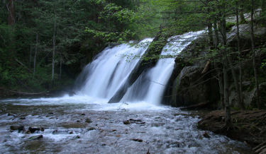
Scenery Summary: The two waterfalls bookending this trail make it a memorable trip. Corlieu Falls, downstream from the trailhead, is an 80 foot (25 meter) series of cascades in a narrow canyon. Red Rock Falls is much shorter, at about 20 feet (6 meters), but compensates in width and concentration of power. The trail to Red Rock Falls is also pleasant in a daydreamy-stroll-beside-a-stream sort of way. It proceeds beside Lewis Creek, which is framed by ferns and mossy rocks, and the trail itself is lined with evergreens and dogwoods. The shady environment produced by the timber and the canyon through which the creek flows give this hike a northwestern flavor, especially in the spring. Google Street View has a few panoramas to help give you an idea of what you'll find along the trail, including one of Red Rock Falls during spring runoff and another of Corlieu Falls from the viewing platform.
Crowd Factor: Pandemic-era restrictions on Yosemite access have made outside-the-park hikes more popular, and Lewis Creek is no exception. It's common now to see cars in the overflow lot around the corner from the trailhead and parking two rows deep at the main lot.
Difficulty: These hikes straddle the easy/medium boundary. Both involve some elevation change, and it's especially concentrated on the Corlieu Falls trail, where you'll have a short but lung-straining walk up a steep trail to get back from the falls. Still, the route is much improved; the Forest Service has built a viewing platform and put lots of work into the trail. If you're familiar with the pre-2010 Corlieu Falls hike and remember the perilous scramble down the slope to see the falls, the changes will impress you. It's now possible to catch an excellent view of the falls without incurring any injuries at all.
Best Time to Visit: In the spring, when there's lots of water going over the falls and wildflowers are blooming along the trail.
Nearest Bathrooms: Portable toilets at the trailhead. Bathrooms with plumbing available in Oakhurst, 6 miles (9.5 km) south; at Fish Camp, 5 miles (8 km) north; or at the Yosemite entrance, 7 miles (11 km) north
Nearest Snacks: in Oakhurst, 6 miles (9.5 km) south, or Fish Camp, 5 miles (8 km) north
Driving Directions: The Lewis Creek trailhead is located on highway 41, seven miles (11 km) south of Yosemite's southern entrance, and 7.5 miles (12 km) north of the intersection of highways 41 and 49 in Oakhurst. Here's a Google Street View panorama of the trailhead parking area.
A hundred meters or so from the trailhead, the trail forks. Go left (upstream) to Red Rock Falls or right (downstream) to Corlieu Falls.
Parking: Lot at the trailhead that holds a dozen or so cars
Hazards: It's the familiar Sierra formula: water = mosquitoes. Bring your repellent. There are also patches of poison oak along the Corlieu Falls section of the trail.
Dog Friendly: Dogs aren't allowed on most of the trails inside Yosemite, but they're welcome on national forest trails like Lewis Creek, provided you keep them leashed.
Already hiked the Lewis Creek trail? Add a Review.