Ten Lakes
Distance: 13 miles (21 km) round trip to the Ten Lakes area; 12 miles (19 km) round trip to the first Grant Lake
Trailhead Elevation: 7,520 feet (2,290 meters)
Peak Elevation: 9,640 feet (2,940 meters)
Trailhead-to-Peak Elevation Gain: 2,120 feet (645 meters)
Total Elevation Gain: 2,700 feet (820 meters)
Why hike the Ten Lakes trail? What, ten lakes aren't enough for you?
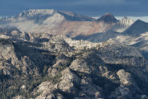
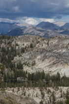
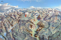
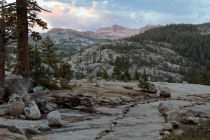
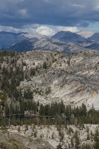
Scenery Summary: Besides the aforementioned lakes, you'll find impressive views to the peaks across the Grand Canyon of the Tuolumne, and a meadow just before the steep stretch climbing to the plateau with those views.
Google Street View hosts a variety of click-worthy panoramas taken from the Ten Lakes Trail. Highlights include the meadow, the first Grant Lake, the plateau at Ten Lakes Pass (which you climb to before descending into the Ten Lakes area), the view of the first two lakes along the descent, and the shoreline of the first lake.
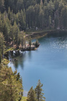
Are There Really Ten Lakes? Yes, there really are: the two Grant Lakes, accessible from a fork off the main trail (see the trail map), and eight additional lakes that, apparently, no one has gotten around to naming individually, so help yourself. The official trails only pass within close proximity of four of the lakes, but even visiting just those four would make for a long day covering more than 15 miles (24 km) round trip and nearly 3,000 feet (900 meters) of elevation gain. Day hikers are likely to feel they've asked enough of their feet by the time they've carried them to the first two lakes on the main trail, which would be around 13 miles (21 km) round trip.
Best Time to Visit: Whenever the Tioga Road is open (June to November, roughly) should be good, though there might be snow on the trail early or late in the season.
Crowd Factor: This trail is popular with backpackers, and understandably so, since it's a pretty area that's hard to cover in a single day hike. Ten lakes, you know. Still, "popular" has a different meaning here than it does in Yosemite Valley: it means passing other hikers a few times an hour and perhaps finding one or two people already at a lake when you arrive.
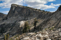
Difficulty: This hike edges into the strenuous category, largely due to its length. The trail climbs steadily but not steeply for the first four-point-something miles to a point where it skirts the western side of a pretty meadow. Then it begins a short but steep climb, complete with switchbacks, up to the Ten Lakes Pass plateau, where, at the five mile mark, the trail forks into Ten Lakes and Grant Lake editions. From here, you'll cross the plateau and then descend to whichever lakes you choose. The descent into the Ten Lakes area is steep and rocky.
Parking: Parking lots on either side of the road at the trailhead, holding perhaps thirty cars in all. Both lots can fill up, though, probably due to those backpackers abandoning their cars here for days at a time. There's additional parking at a picnic area just around the corner. Here's a Google Street View panorama of the trailhead area.
Nearest Bathrooms: Pit toilets at the trailhead.
Nearest Snacks: A tiny general store occupies one corner of the main building at White Wolf, 5 miles west and a mile north. There's a larger shop and gas station at Crane Flat, 20 miles west, and another at Tuolumne Meadows, 18 miles east. None of these keep late hours. If you plan to get back after dark and think you'll be craving a snack, best to buy it ahead of time and stash it in one of the food-storage lockers.
Food Storage Lockers: Several at the trailhead parking area.
Getting There: 20 miles (32 km) east of Crane Flat (the Tioga Road's western terminus); 5.1 miles (8 km) east of the White Wolf turnoff; 25 miles (40 km) west of Tioga Pass (Yosemite's eastern entrance). See the trailhead location map for more details.
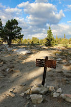
Trail Notes & Hazards: About a mile into the hike, the trail crosses an expansive patch of granite, and depending on the current state of the rock cairns that mark the way, it can be tricky to find where the trail resumes on the other side. You can help save yourself some getting-lost-in-the-wilderness adventures by returning early enough that you don't have to navigate this stretch by flashlight.
There are stream crossings along the route, and you may encounter mosquitoes early in the summer.
The trail climbs gradually northeastwards, mostly through forest, for the first four+ miles. After traversing the western edge of a large meadow, you'll have a short, steep climb to the Ten Lakes Pass plateau. The Grant Lakes trail fork departs from the south end of the plateau (fork photo here). A quarter mile or so farther along, at the north end of the plateau, you'll have views northwards across the Grand Canyon of the Tuolumne (the Tuolumne River lies out of sight some 4,000 feet/1,200 meters below) to a variety of peaks, some surpassing 10,000 feet (3,000 meters) in elevation. You should also be able to look down and see three of the Ten Lakes off to the east. If it's your first time on the Ten Lakes Trail and you're planning to just visit the Grant Lakes, it's worth detouring beyond the trail fork for these views.
Already been to Ten Lakes? Submit a Review.