Sentinel Dome
Distance: 2.2 miles (3.5 km) round trip
Elevation at trailhead: 7,700 feet (2,345 meters)
Final Elevation: 8,100 feet (2,470 meters)
Hiking Time: 1 - 2 hours
Why Hike to Sentinel Dome? To visit the fallen Jeffrey pine, formerly one of the most famous trees in the world. To finally have a reason to use the 360-degree-panorama-stitching software that came with your camera.
Best Time to Visit: Any time Glacier Point Road is open. And when it's closed, too, for that matter, if you're an adept cross-country skier.
Difficulty: Mostly easy. It requires little effort until the final stretch up the dome itself, which is short but steep. If it's your first day in Yosemite, you might feel the effects of the elevation - the trailhead is 3,500 feet (1,000 meters) higher than Yosemite Valley.
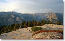
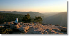
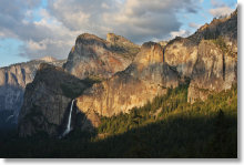
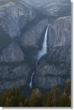
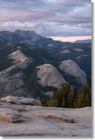
Scenery Summary: Hiking to the top of Sentinel Dome is by far Yosemite's easiest way to experience miles and miles of views in whatever direction you care to turn. Looking west, you'll see down Yosemite Valley and beyond to the Merced River canyon and, on exceptionally clear days, all the way to Mt. Diablo in the coastal range. To the north you'll see Yosemite Valley, including El Capitan and Yosemite Falls. To the east, you'll see Nevada Fall, Half Dome and Clouds Rest, and an assortment of High Sierra peaks.
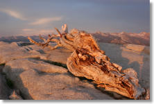
To the south, the views are comparably pedestrian, I'm sorry to report. Instead of wasting your eyes looking that way, contemplate instead what may be the world's most famous dead tree: the Jeffrey pine on the summit. About the same age as Shakespeare, it's been photographed thousands of times, but it got its first big break and became a star after it appeared in this 1940 Ansel Adams photo. The tree was killed by drought in 1977, despite attempts to save it by hand-carrying buckets of water up the dome to it, and it finally fell over in 2003.
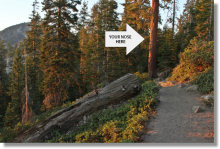
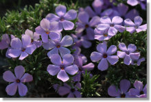
The trail to the dome is pleasant but not particularly remarkable. You'll cross a bridge over a picturesque brook at the beginning of the hike, and if your timing is good, you may see a few dozen varieties of wildflowers, with large doses of spreading phlox, penstemon, and larkspur, among others. You'll also pass some mature Jeffrey Pine trees next to the trail. If you shove your nose into the bark and take a deep whiff, you'll catch the aroma of butterscotch (or, some say, vanilla). If you don't smell anything, you might have accidentally made your advances to a Ponderosa pine, which has similar looking puzzle-piece bark.
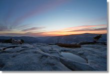
Virtual Yosemite has a panorama of the top of dome that lets you see all 360 degrees of the view here, and Google Street View has so many that it's virtually impossible to state with confidence that that you've seen them all; each time you zoom in, lone street view dots transform into ragged clusters of them, a sort of panoception. But a few notable ones include this lovely near-sunset view; this one showing the view of Yosemite Falls (look for the falls just to the right of the two head-free bodies); this one showing the last stretch of the trail to the top of the dome (which, incidentally, is much steeper looking in person); and this one, in which Nevada Fall can be seen.
Crowd Factor: Medium. Maybe it's the short trail or maybe it's my overwhelming personal charisma, but I've never been alone here. It's nothing like the crowds, though, at Glacier Point, the area's leading attraction.
Parking: Sentinel Dome shares its trailhead with Taft Point, and the repaving project that kept the Glacier Road closed for all of 2022 supplemented the trailhead's frequently-full full lot with an overflow lot just to the west and some further pullout parking to the east, though empty spots can still be hard to find.
Nearest Bathrooms: Pit toilets at the trailhead and in the overflow parking lot.
Nearest Snacks: gift shop & cafeteria at Glacier Point, 7.5 miles (12 km) farther down the road (closes at 7 pm and closed all winter)
Food Storage Lockers: At the trailhead and in the overflow parking area.
Getting There: From the South entrance to Yosemite, turn left and travel 17.3 miles (27.7 km) to Glacier Point Road. From the valley, take road 41 nine miles (14.5 km) to the same road. Once you're on Glacier Point Road, follow it to the trailhead 13.6 miles (21.8 km) later. Here's a Google Street View panorama of the trailhead area. It predates the 2022 construction project, but things still look roughly similar.
Hazards: The top of the dome is large and only slopes mildly, but it gets steeper as you approach the edges. You probably wouldn't want to let your kids wander alone here.
Chill winds sometimes kick up on the top of the dome around sunset. It doesn't happen every evening - the pattern I think I've detected is that it only occurs if there's someone there who didn't bring a jacket. So don't be that guy. If you are that guy, you can usually retreat down to the shoulder of the dome and warm up again.
This trail, along with all the others along Glacier Point Road except Glacier Point itself, is usually still covered with snow for the first few weeks after the road opens. If you try to hike it anyway, you'll probably end up following the footprints of the hikers who've gone before you and hoping they knew where they were going.
The Yosemite Conservancy maintains a webcam along the northeast shoulder of Sentinel Dome that can give you an idea of how much snow's left. Since the webcam captures a north-facing slope that's also shaded by the dome, there may be more snow here than you'll find on the rest of the trail.
In March of 2007, performance artist Adam Long spent a day building a pair of snowmen in front of the webcam; you can see a time-lapse video of the project (select March 5, 2007 and the Sentinel Dome camera, then click the "View Movie" button). This might not sound like a particularly challenging endeavor, but keep in mind that once Glacier Point Road is closed for the winter, it's a nine-mile (14 km) snowshoe or ski trip to reach the webcam. Not only that, but Mr. Long's life may have been in danger the entire time, since Bigfoot was later spotted on the same webcam.
Even Easier Alternate Route: The main trail isn't a particularly difficult hike, but the service road, which joins the main trail at the base of the dome, is even shorter, coming in at around two thirds of a mile. It might be easier to find this route if you're returning from the dome after dark or if you're hiking during the first few days after the Glacier Point Road opens, when the trail is usually still covered with snow. The trailhead is roughly 0.7 miles (1.1 km) east of the regular trailhead (i.e., farther along the road towards Glacier Point). There's a pullout for parking on the right and a gate across the service road on the left. Here's a Google Street View panorama of the service road trailhead area.
Already done this hike? Add a Review.