McGurk Meadow
Distance: 1.8 miles (2.9 km) round trip
Trailhead Elevation: 6,900 feet (2,100 meters)
Elevation Change: 100 feet (30 meters)
Hiking Time: 30 - 60 minutes
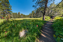
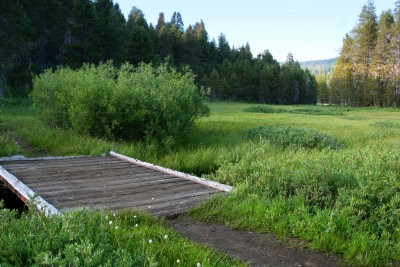
Why hike to McGurk Meadow? McGurk Meadow is found money, the sprinkles on the ice cream, the Irish in the coffee: it's a bonus hike you can knock off whenever you have a free hour or two, an unheralded lagniappe that makes you feel like you've gotten the extra mileage out of Yosemite. It's a sun-dappled stroll through the woods to a wildflower-filled, brook-running-through-it meadow, over a smooth trail that doesn't require lots of concentration and allows your mind to go wandering where it will.
Difficulty: A solid 1 out of 10. There's a slight incline on the return trip, but you'll find little else to complain about. This is one of Yosemite's most leisurely strolls.
Best Time to Visit: The Glacier Point Road is open from June through October, roughly. The meadow is interesting anytime, but it's hard to beat June and July, when you're most likely to find a green meadow accompanied by dozens of varieties of wildflower in bloom and a full brook.
Crowd Factor: Generally low. As evidenced by the lack of a parking lot for this trailhead, which also serves Dewey Point, Stanford Point, Crocker Point, and Westfall Meadow, this is still a largely undiscovered trail.
Nearest Bathrooms: There's a pit toilet at Summit Meadow, just over a mile west. The nearest plumbing is at Chinquapin (the Glacier Point Road/Highway 41 junction), 7.5 miles (12 km) west.
Nearest Snacks: At the Glacier Point cafeteria/gift shop, 8 miles (13 km) east.
Getting There: If you're in Yosemite Valley, take highway 41 south for nine miles (14.5 km) to the Glacier Point Road. From Yosemite's southern entrance, take highway 41 north for 17 miles (28 km) to the Glacier Point turnoff. The turnoff is well marked, and it's the only eastbound road for several miles in either direction.
From Glacier Point Road, travel east for 7.5 miles (12 km) to the trailhead. There's no parking lot here; watch for the "McGurk Meadow" sign on the north (left) side of the road. It's about a mile past Summit Meadow, which will be on your right and have a broad pullout with an outhouse. If you get to the Bridalveil Creek Campground, you've gone just past it. Here's a Google Street View panorama of the trailhead area, though it's easier to find now than it was when this street view was filmed since there's parking next to the trailhead.
Parking: One of the improvements from the repaving project that kept the Glacier Point Road closed for all of 2022 was a new parking area for Dewey Point/McGurk Meadow, right at the trailhead instead of away off down the road, and with room for about 40 cars.
Food Storage Lockers: At the trailhead.
Hazards & Trail Notes: As with just about any meadow in Yosemite, if it's wet enough that the meadow is still green, you'll want mosquito repellent.
Already been to McGurk Meadow? Add a Review.
McGurk Meadow Panoramas
From Virtual Yosemite