Chilnualna Falls
Distance: 8.4 miles (13.5 km) round trip
Trailhead Elevation: 4,200 feet (1,280 meters)
Elevation Gain: 2,300 feet (700 meters)
Hiking Time: 4 - 6 hours
Why hike to Chilnualna Falls? While Yosemite Valley's Mist Trail is world famous for its two waterfalls, the Chilnualna Falls trail has three, plus some lively bonus cascades near the beginning of the trail. It's also practically deserted compared to the Mist Trail. The tradeoffs: it's difficult to get near the uppermost falls at high water or to get near the tallest one at all, and the Mist Trail's falls are taller and, being fed by a larger river, more spectacular. The Chilnualna Falls hike during peak runoff is undoubtedly a memorable experience, though, and it might see fewer hikers over the entire summer than Vernal Fall does during any given June Saturday.
Difficulty: Fairly strenous. It's not as steep as the most challenging stretches of the Mist Trail, but it climbs relentlessly and it's a long hike.
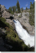
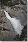
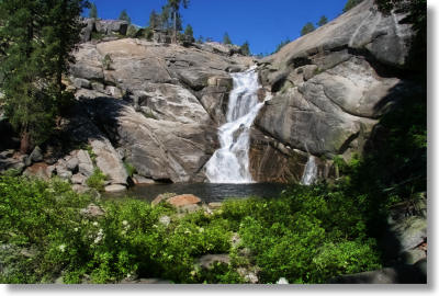
Scenery Summary: Chilnualna Falls consists of a 50-foot (15-meter) fall (pictured above), followed by a series of pools and a 100-foot cascade, followed by a 240-foot (70-meter) capper of a cataract. Unfortunately, the trail doesn't give you a particularly good view of the climactic fall. You see it from the side when you're a quarter mile or so away, but then the trail disappears into the woods and you don't see it again until the trail opens up near the granite shelf above the fall. You can't get close enough from here to peer over and look down on the 240-foot fall (not the best point of view for a waterfall, anyway) without making it likely that the author of Off the Wall: Death in Yosemite will have to rush out a revised and enlarged edition. So until the park stewards build a viewing platform (which would be welcome at Illilouette Falls, as well), you'll have to be content with hanging out by the cascades and lounging around the upper falls.
Best Time to Visit: In the spring, when there's plenty of water rushing over the falls. This relatively low-elevation hike can get unpleasantly hot by midsummer.
Crowd Factor: Light but not lonely.
Nearest Bathrooms: There are outhouses at the trailhead parking lot. If you have a sensitive nose, you can find bathrooms with plumbing at the Wawona Hotel and at the far end of the Wawona General Store/Pioneer History Center parking lot, about two miles away.
Nearest Snacks: At the Pine Tree Market, half a mile back the way you came. There's also a general store and restaurant at Wawona, roughly two miles (3.2 km) away.
Getting There: Start by finding the Wawona Hotel and General Store in southern Yosemite. They're five miles (8 km) north of the south entrance and 21 miles (34 km) south of Yosemite Valley on Highway 41.
Once you're at the Wawona, drive north across the bridge crossing the South Fork of the Merced River and then turn right on Chilnualna Falls Road. It'll be the first right after the bridge, about a hundred meters north of it. Once you're on Chilnualna Falls Road, go just over 1.5 miles (2.5 km) to the trailhead parking lot, which will be on your right. Here are Google Street View panoramas of the Chilnualna Road turnoff, the turnoff to the parking area, and the trailhead area.
Parking: There's a dirt lot near the trailhead. It holds twenty or so cars, and it's rarely full.
Trail Notes and Hazards: After you park, walk back up to Chilnualna Falls Road and hike another hundred meters or so along it to reach the trailhead. The trail forks here, though the forks rejoin after about a quarter mile. The right fork is for hikers only, the left for horses. The hikers-only fork is more scenic, climbing past a series of bonus cascades that are worth a visit all by themselves.
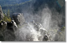
Avoid getting too close to the stream near the falls when the water's high. The combination of fast water and slippery granite riverbed make clambering out again an unlikely bet, no matter how motivated you may be by the 240-foot precipice you're sliding towards.
If you hike early enough in the year, you'll have to cross two streams too wide to jump before you reach the falls. Both are shallow and have log crossings, and shouldn't present much difficulty. If you want to get all the way to the top of the uppermost cascade, though, you'll have to ford a third stream that's deeper and more challenging. You can indulge your inner acrobat and try the rather tenuous log crossing a short ways downstream if you like, but if you're hiking during the high water period, figure on getting wet whichever route you take.
There's poison oak along the trail, though not much of it. I've also seen a rattlesnake about as big around as - oh, I don't know, let's say one of your smaller twin engine aircraft - crossing the road near the trailhead. This area should be nearing the top of their range, though; it might have just been somebody's pet.
Already done this hike? Add a Review.