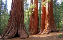
Tuolumne Grove of Giant Sequoias
Distance: 2.5 miles (4 km) round trip
Elevation at trailhead: 6,200 feet (1,860 meters)
Elevation Gain: 400 feet (120 meters) elevation loss to the grove.
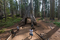
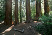
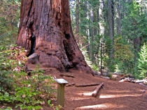
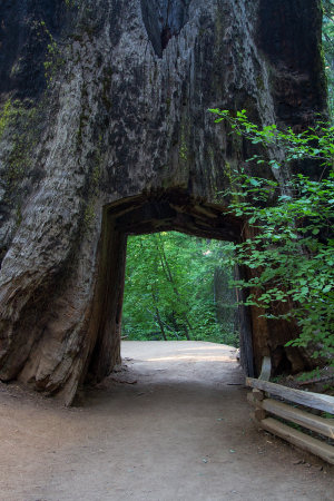
Why visit the Tuolumne Grove? If you're a dessert-first kind of person, the Tuolumne Grove trail was made for you: the entire trip to the grove is downhill. Oh, and the grove itself contains a couple dozen mature Giant Sequoias, including one you can walk through (although it's dead - but then, you would be too).
Hiking Time: 1.5 - 2.5 hours
Best Time to Visit: The Sequoias should be equally scenic whenever Tioga Road is open - June through October, generally - but it might be best in the Autumn, when the deciduous trees are changing colors. Parts of the grove sometimes get closed late in the year, though.
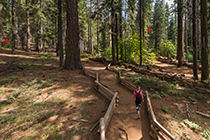
Difficulty: It's an easy hike over a short, smooth trail. The only downer (so to speak) is that you'll have to climb 400 feet on the route back to the trailhead.
Crowd Factor: Not as crowded as the Mariposa Grove, but you'll still find no shortage of fellow travelers unless you're there during inclement weather or very late in the season.
Parking: Large lot at the trailhead
Food Storage Lockers: In the parking area
Nearest Bathrooms: At the trailhead (outhouse variety)
Nearest Snacks: At Crane Flat gas station, half a mile back towards Yosemite Valley
Getting There: From Yosemite Valley, take highway 120 ten miles (16.8 km) to the Crane Flat/Tioga Road turnoff, then take Tioga Road half a mile (0.8 km) east to the Tuolumne Grove parking lot. From Yosemite's east entrance at Tioga Pass, take the Tioga Road west 47 miles (75 km) to the lot. Here's a Google Street View panorama of the trailhead parking area.
Tuolumne Grove Panoramas
From Virtual Yosemite