Panum Crater
Hike Distance: 1 mile (1.6 km) round trip for Plug Trail;
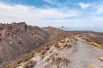
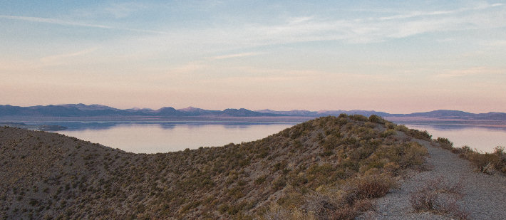
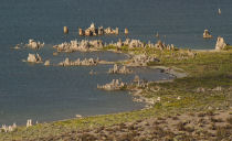
1.5 miles (2.4 km) loop for Rim Trail (pictured above)
Trailhead Elevation: 6,840 feet (2,080 meters)
Elevation Gain: 200 feet (60 meters)
Distance from Yosemite: 21 miles (34 km)
Hiking Time: 30 minutes - 2 hours
Why visit Panum Crater? Panum Crater is, per the sign at the trailhead, "a perfect example of a rhyolitic plug-dome volcano," and this is more interesting than you realize. (Unless you're a geologist, in which case it's exactly as interesting as you realize. Possibly a bit less.) Panum is basically a temporarily frozen tableau recording a period of awesome violence some 680 years ago, when rising magma met the water table with electrifying results: the water, prevented from boiling by the pressure of the overlying ground, superheated and exploded, blasting through the Earth's surface to carve out a crater half a mile across; meanwhile, the magma ascended through the newly made channel and sorted itself into a 200-foot-high mound in the center of the crater. This USGS aerial photo of Panum Crater illustrates the resulting confection. Today you can hike both the pumice ring that surrounds the crater (the Rim Trail) and the central dome (the Plug Trail).
You probably think of the 14th century CE as the distant era of Chaucer, Dante, and Wladyslaw the Elbow-High. In geological terms, though, it's about as long ago as you started reading this sentence, so it shouldn't be surprising to learn that the Panum plume, which last erupted during that era, isn't dead, just napping, and is likely to reawaken at some point. Hike the Plug Trail and you could be the one to find the first telltale tendrils of steam announcing that Panum is resuming operations and it's time to evacuate Mono County to a more placid planet somewhere nearby.
What are the chances of this? A 2019 USGS survey of volcanic hazards in California estimated that for the Long Valley Volcanic Region, an area stretching from the Mammoth Lakes region in the south to just north of Mono Lake, and including Panum Crater, there's a 2.5% chance of eruption in the next 10 years and a 22.5% chance in the next hundred years. (See page 16 in the survey's PDF for Panum-Crater-relevant stuff.) So not particularly likely, but at least better than your chances of winning the lottery or getting adopted by marsupials.
What would happen if Panum Crater erupted? We have to interpolate a bit for this, since the projected damage radii from the survey mentioned above cover the entire Long Valley Volcanic Region rather than just Panum Crater. However, volcanoes here, including Panum, are considered likely to produce explosive eruptions, spewing rivers of volcano guts traveling at highway speeds and launching boulders that fly for miles before landing. (The earth, it turns out, is endearingly like people in this respect: when it throws up, you want it to be pointed away from you.) In the event of a Panum Crater eruption, it appears likely that Highway 395 would be closed and Lee Vining would need to be evacuated, and there's a good chance that the neighboring Mono Lake South Tufa Trail would be buried. Volcanic ash from the eruption, while arguably having a less immediately life-altering impact than a boulder does when it lands on you, would cover a much wider area, falling on all of Yosemite Park and reaching the foothill communties outside its western boundaries, though probably not extending all the way to the Central Valley. The park service has closed Yosemite before when smoke from wildfires reached dangerous levels and would probably also close the park if the air were thick with volcanic ash, which can cause respiratory problems.
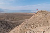
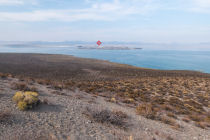
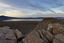
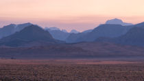
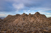
Scenery Summary: Aside from the disquieting knowledge that you're walking on a living volcano, you're likely to be most struck by the views of Mono Lake (to the north) and the Sierra range (to the west). The Plug Trail leads to a high overlook where both are visible, along with the vast sagebrush plains in between. The rubble at your feet here is primarily the remains of spires formed by lava squeezing through cracks in the cooling dome; a few spires remain upright and look commendably stoic, in the way that rocks are especially good at, despite the ominous wreckage strewn all about them. (Here's a Google street-view panorama of the Plug Trail showing one of the spires.)
Crowd Factor: Light. What hikers there are tend to be scattered around the site rather than piled up at a central viewing area.
Difficulty: Low. Granted, there's some climbing, but both trails are fairly short. The central plug looms well above the surrounding rim, but given the Rim Trail's sine-wavey profile, you'll probably end up with about the same amount of climbing on either trail. The crushed pumice that comprises much of the trails has a sandy, beach-like texture that makes walking a bit more difficult than normal. On the other hand, walking downhill through a layer of ground pumice is rather fun, mildly reminiscent of striding along those moving walkways in airports, though of course no mere hiking trail can hope to replicate all the glories of an airport terminal.
Best Time to Visit: The Mono Lake basin has a knack for producing memorable sunsets (and possibly sunrises as well, though who would know?), and a sunset either here or at the nearby Mono Lake Tufa Trail is unlikely to feel misspent. The road is generally closed in the winter.
Parking: Room for 15 or 20 cars at the trailhead.
Nearest Bathrooms: Pit toilets at the South Tufa Trail parking area, 2 miles (3 km) farther east; toilets with plumbing at the gas station/deli near the Tioga Road/395 intersection, 8 miles (13 km) back to the northwest. There are no bathrooms at Panum Crater itself. Trees are scarce, too, but some of the sagebrush are pretty big.
Nearest Snacks: Convenience-mart snacks and the famous Whoa Nelli Deli await at the gas station near the Tioga Road/395 intersection, which you'll pass on your way to the trailhead from Yosemite.
Getting There: See the driving map.
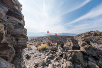
Trail Notes & Hazards: Careering off the Rim Trail is likely to lead to you sliding down the hill until you're stopped by pumice friction or a collision with a surprised sagebrush, but there are spots along the Plug Trail (particularly the viewpoint at the end of the trail) where it's possible to fall and suffer serious injury if you're careless. The last half of the Plug Trail is dotted with rocks that have no qualms about tripping inattentive hikers - they were here first and they're not moving, apparently.
The 0.8-mile (1.3 km) road from Highway 120 to the Panum Crater parking lot is unpaved, composed of a fairly washboardy gravel, and only one lane wide, with periodic pullouts. Should you encounter a car coming the other way, someone's going to have to back up. If you're visiting from overseas, you've probably heard that the American practice in these situations is for the adversaries to emerge from their vehicles and hold a dance-off, with the winner gaining right of way, but in my experience, this custom is no longer universally observed. It's a shame, really, how the old folkways are disappearing.
If Panum Crater is erupting, leave with all possible dispatch.
More Photos
Panum Crater Panoramas
From Virtual Yosemite