Bridalveil Creek
Hike Distance: 6.6 miles (10.5 km) out and back or 5.5 mile (9 km) loop
Trailhead Elevation: 7,000 feet (2,100 meters)
Total Elevation Gain: 100 feet (30 meters)
Hiking Time: 3 - 6 hours
Why hike the Bridalveil Creek trail? This is a change-of-pace hike: an intermission between acts, a cartoon sandwiched between the news stories, a slice of ginger to cleanse your palate. It's not impressive by Yosemite standards, but it's a pleasant, uncrowded, and largely climb-free walk in the woods, with meadows along the first half and Bridalveil Creek along the second half. If your expectations aren't too high, you'll enjoy it.
Crowd Factor: Light. This hike is part of the trail to Ostrander Lake, but it's not generally regarded as a destination itself.
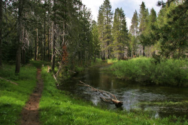
Scenery Summary: The first leg of the hike tracks through meadows and past seasonal streams. At the right times of year (late June through July, though show times and quality vary), it'll be a vast sea of wildflowers. The second leg wanders back towards Glacier Point Road along Bridalveil Creek, whose chilled out waters give no signs of awareness of the thrill ride they're headed for a couple miles downstream, when they plunge over Bridalveil Fall.
Difficulty: Mostly easy, but you'll have to ford Bridalveil Creek, and there may be fallen logs on the trail to climb over.
Best Time to Visit: In the early summer (which will be spring at this elevation), when the meadows are green and wildflowers are blooming
Nearest Bathrooms: Pit toilets at the trailhead.
Nearest Snacks: At Glacier Point, the end of the road, 7 miles (11 km) farther east.
Driving Directions: From Yosemite's southern entrance, turn north (left) and proceed 17.3 miles (27.7 km) to Glacier Point Road. From Yosemite Valley, take road 41 nine miles (14.5 km) to the same road. Once you've reached Glacier Point Road, follow it to the Ostrander Lake trailhead 9 miles (14 km) down the road. (This hike shares its trailhead with the Ostrander Lake trail.)
Forks in the Trail: You'll encounter two of them. In each case, turn right (the left forks lead south to Ostrander Lake and Chilnualna Falls, respectively). You'll also have a decision to make once you reach Bridalveil Creek Campground at the end of the second leg: turn back and make the hike a longer, V-shaped out-and-back, or continue through the campground and hike a little over a mile along the narrow-to-absent shoulders of Glacier Point Road to get back to the trailhead.
Route Details: from the Ostrander Lake trailhead, hike 1.4 miles (2.2 km) to the first fork in the trail. Turn right (the left fork continues to Ostrander Lake) and proceed 0.3 miles (0.5 km), crossing Bridalveil Creek and reaching the next fork. Again, turn right, and hike 1.6 miles (2.5 km) to Bridalveil Creek Campground. At this point, you have a choice: turn around and go back the way you came, or hike through the campground and then east along Glacier Point Road to get back to the trailhead.
Parking: Dirt lot at the trailhead.
Hazards: You'll have to ford Bridalveil Creek after passing the first trail fork, about halfway through the hike. The water could be knee-high or deeper, depending on the time of year and how much snow there was the previous winter. There's a mildly perilous log crossing a hundred meters or so upstream and an acrobats-only crossing about halfway there, if they haven't washed away.
If you choose to make this hike a round-trip triangular loop rather than a V-shaped out-and-back, you'll have to hike along Glacier Point Road for more than a mile to get back to the trailhead, and the shoulders are wafer thin here.
You'll likely have to climb over or around fallen logs on the first leg of the trail.
Finally, meadows and creek banks are prime mosquito territory. Bring your repellent.
Already done this hike? Add a Review.