Ostrander Lake
Hike Distance: 12.4 miles (20 km) round trip
Trailhead Elevation: 7,000 feet (2,130 meters)
Ostrander Lake Elevation: 8,500 feet (2,600 meters)
Total Elevation Gain: 1,600 feet (490 meters)
Hiking Time: 5 - 8 hours
Why hike to Ostrander Lake? In the height of winter, people strap on skis and slog ten miles from Badger Pass to get to this lake just so they can take a quick look around, collapse with exhaustion in the ski hut, and ski back the next day. If they think this is worth it, the rest of us can hardly gainsay the shorter hike up the snow-free, wildflower-strewn trail to the lake in the summer.
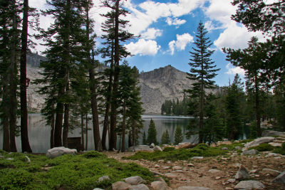
Scenery Summary: Ostrander Lake is one of those pretty, granite-wrapped mountain lakes that are typical of the High Sierra. On the first half of the hike you'll go through meadows and past streams, and if you're there at the right time of the year, you'll see more wildflowers than you can count - not just in the meadows and along the stream banks, but throughout the hike. On the latter part of the trail, you'll go through a high clearing that opens up to views of the back of Half Dome and beyond.
Google Street View has a panorama of the lake that's pretty and worth scrolling around, though it doesn't offer a full view of the mountains south of the lake. Here's hoping that one of the Ostrander Ski Hut visitors will make a panorama for us in deepest winter sometime soon.
Crowd Factor: Medium. Ostrander Lake is a popular stop for backpackers.
Difficulty: Medium. It's a long hike, but at least you'll be able to warm up with some pleasant strolling through meadows before the onset of the climbing, which is mostly on the latter half of the trail.
Best Time to Visit: Any time Glacier Point Road is open, Ostrander Lake should be pretty. This trail gets bonus points during wildflower season, which runs roughly from the end of June through July. The best trip to Ostrander Lake, though, might be in mid-winter, when the Ostrander Ski Hut serves as an overnight lodge for cross-country skiers. The meadows along the early parts of the trail can be marshy in late May and early June.
Nearest Bathrooms: Hole-in-the-ground variety at the trailhead.
Nearest Snacks: At Glacier Point, the road's terminus, 7 miles (11 km) farther east.
Driving Directions: From the South entrance to Yosemite, turn north (left) and proceed 17.3 miles (27.7 km) to Glacier Point Road. From the valley, take road 41 nine miles (14.5 km) to the same road. Once you're on Glacier Point Road, follow it to the trailhead 9 miles (14 km) down the road. Here's a Google Street View panorama of the trailhead turnoff.
Parking: Large lot at the trailhead.
Food Storage Lockers: At the trailhead.
Hazards: The meadows you hike through on the first half of the trail are almost certain to be harboring mosquitoes. They can get swampy (the meadows, not the mosquitoes) right after rainstorms, as well.
Useless Information: Ostrander Lake was named for a sheepman (a demonic half sheep/half man creature from the abyss, or merely a man who raised sheep? historical records are not explicit on this vital point) who lived near the current trail in the 1860s.
Already been to Ostrander Lake? Add a Review.