Upper Yosemite Falls
Distance: 7.6 miles (12 km) round trip from the Lower Yosemite Falls trailhead; 9.4 miles (15 km) including Yosemite Point
Elevation at trailhead: 3,967 feet (1,347 meters)
Elevation at top of Yosemite Falls: 6,526 feet (1,989 meters)
Elevation at Yosemite Point: 6,936 feet (2,114 meters)
Elevation gain: 2,600 feet (790 meters) to the top of Yosemite Falls; 2,969 feet (890 meters) to
Yosemite Point
Hiking Time: 6 - 10 hours. Don't double-book hikes on days when you've got this one on your schedule.
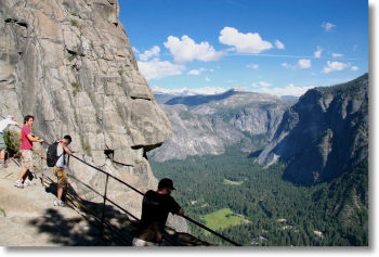
Why hike to the top of Yosemite Falls? It's the mother of all stairmaster workouts, but with one-of-a-kind payoffs you won't get in a gym: panoramic views of Yosemite Valley; the only place outside Sentinel Dome where all of Yosemite Falls is visible (though you can't actually see it all at once unless you've got Exorcistesque peripheral vision); the chance to walk through the spray from upper Yosemite Falls; the chance to photograph Yosemite Falls and Half Dome in the same frame; and from Yosemite Point, closeup views of Half Dome that you can only beat by climbing North Dome.
Best Time to Visit: In the spring or early summer, when the falls are roaring. By August the falls have typically dwindled to a trickle, and by the end of summer they often dry up altogether. Check out the Yosemite Falls webcam to see how much water is currently flowing over the falls. (If this link isn't working, visit the main webcams page and then click on the Yosemite Falls thumbnail. There's also a streaming version of the webcam.)
Crowd Factor: As with any trail that starts in Yosemite Valley, this one has plenty of people on it. It's got a friendlier vibe than the fall-out-of-your-car-and-you're-there attractions, though, because of the strenuousnosity of this hike. Your fellow hikers know they might need your help to carry them back down the trail again.
Difficulty: High. It's a long, steep climb from the valley floor to the valley rim, and easily rates an 8 out of 10. Consider this question: would you climb the stairs all the way to the top of the Empire State Building? Well, in the course of your hike to Upper Yosemite Falls, you'll climb the equivalent of just over two Empire State Buildings.
Parking: Anywhere near Yosemite Lodge or Yosemite Village will work out well - the day-use lot just south of Yosemite Village is your likeliest bet in this area. If you can't find space near the trailhead, you can park just about anywhere in eastern Yosemite Valley and catch a free shuttle to the trailhead.
Nearest Bathrooms: At the trailhead (meaning, in this case, the Lower Yosemite Falls trailhead). There are no bathrooms along the trail itself.
Nearest Snacks: At Yosemite Village, half a mile to the east.
Hazards: There are mosquitoes along this route. There are a few spots, particularly the viewpoints, where the dropoffs are sheer and the guardrails welcome. Don't bring along any friends whose medication has led them to believe they can fly. And don't, under any circumstances, fall into the river above the falls.
This hike is a challenging workout. You won't make it unless you're in decent shape and you've brought enough food and liquid to carry you through a long, hard climb.