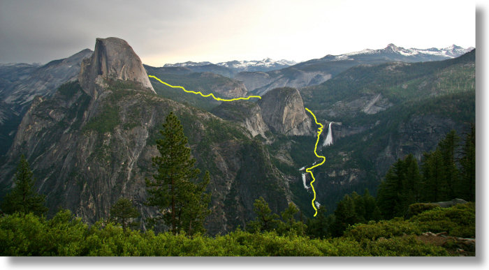
The Route: Part 1 (optional squiggle-free version)
A scouting trip to
Glacier Point, where this photo was taken, will give you a good overview of the
route to Half Dome, even if the real Glacier Point vista doesn't have these handsome yellow trail doodles.
You start in Yosemite Valley, a little to the left of and below your field of vision, then hike south
to the canyon where the waterfalls of the Mist Trail live. You'll hike up the right side of
Vernal Fall
(the lower fall in the photo), including a grueling set of steps carved into the
cliff wall for the last few hundred meters
to the top of the fall. If you hadn't worked up a sweat yet, you will on this stretch. If you're hiking in the
spring or early summer, the mist from Vernal Fall will provide some solace.
About half a mile above Vernal Fall, you'll cross the Merced River again and head up the left side of the canyon to the
top of Nevada Fall. The stretch up the canyon beside the fall is steep and switchbacked. At the top are pit toilets
and benches where you can catch your breath and celebrate the fact that although you may be less than halfway there,
you are about to get a respite from climbing.
The Mist Trail ends at the top of Nevada Fall. Beyond here, the trail
takes a mostly flat route for a mile through Little Yosemite Valley, some of it beside the Merced River,
before angling left to make your way up to Half Dome's eastern shoulder, which you can see in
part 2.