
The Tioga Road
Tioga Road may be off Broadway, but it's remoteness, not quality, that's the cause. Most visitors enter Yosemite through one of the three western gates, and far more people spend their time cavorting in Yosemite Valley than make the winding drive up to see the brightest lights of the Tioga region, which are at the eastern end of the park.
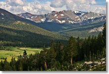
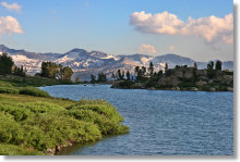
It's worth the trip, though. Tenaya Lake and Tuolumne Meadows would be stars in any lineup, and the Tioga Road area is packed with overlooked gems like the Gaylor Lakes trail. The Tuolumne Grove, though not as large as the more famous Mariposa Grove, still contains dozens of thousand-odd-year-old Giant Sequoias. The numbers are in your favor, too: there are more hikes along the Tioga Road than in any other part of Yosemite.
Current Status: The road is open for the 2026 season. See the park service website's current conditions page for the latest official status, including delays, closures, and whatnot. You can also get a more detailed description of park road conditions by calling the information hotline at 209/372-0200 and choosing 1 from the first two voice prompts. For the status of roads outside the park, visit the CalTrans Road Conditions page and type in a highway number; the roads of note for Yosemite visitors are 41 (leading to the south entrance), 140 (the west entrance at El Portal), and 120 (the north and east entrances). Finally, during the period between winter's end and the road opening, check the Tioga and Glacier Point Road Plowing Updates page for an idea of how much work still needs to be done.
Lodging
There are both wood-frame and tent cabins at the White Wolf Lodge, which lies about 15 miles (24 km) from the Tioga Road's western intersection at Crane Flat. The Tuolumne Meadows Lodge, just east of Tuolumne Meadows, is not a lodge at all, but a series of tent cabins. Like the Tioga Road itself, these accomodations are summer only. They're usually reserved months in advance, but you can check for availablity here.
Food
You can buy snacks at Crane Flat and at the Tuolumne Meadows store. If you're the sort who likes to photograph the sunset on your hikes and doesn't get back to the trailhead until dusk is falling, you'll likely find these both closed by the time you reach them. There's a cafe at the Tioga Pass Resort, just east of the park.
Gas
You can buy gas at Crane Flat, the western terminus of the Tioga Road, and at the store near the east end of Tuolumne Meadows. Make sure your credit card is well below its limit.
You'll also find various gas, food, and lodging options 12 miles (19 km) east of the Tioga Pass entrance at
Lee Vining, where the Tioga Pass Road meets Highway 395.
Tioga Road Hikes
| Trail | Distance miles (km) |
Elevation Gain feet (meters) |
Crowd Factor | Scenery Factor | Difficulty |
|---|---|---|---|---|---|
| Cathedral Lakes | 8.2 (13.2)* | 800 (240)* | |||
| Clouds Rest | 14.5 (23.3) | 1,775 (540) | |||
| Dog Lake | 2.8 (4.5)* | 750 (225)* | |||
| Elizabeth Lake | 4.6 (7.4) | 900 (270) | |||
| Gaylor Lakes | 3 (4.8)* | 600 (180)* | |||
| Glen Aulin (Tuolumne Falls/White Cascade) | 13 (21) | 600 (180) | |||
| Harden Lake | 5.8 (9.3) | 300 (90) | |||
| Lembert Dome | 2.8 (4.5)* | 900 (275)* | |||
| Lower Gaylor Lake | 4.6 (7.4)* | 800 (245)* | |||
| Lukens Lake | 1.6 (2.5)* | 200 (60)* | |||
| Lyell Canyon | 1.4 (2.2)* | < 100 (30)* | |||
| May Lake & Mt. Hoffmann | 2.5 (4)* | 500 (150)* | |||
| Mono Pass | 7.4 (12)* | 900 (275) | |||
| North Dome | 8.8 (14.2) | -560 (-170) | |||
| Olmsted Point | 0.25 (0.4) | < 100 | |||
| Pothole Dome & Tuolumne River | 2.5 (4) | 250 (75) | |||
| Snow Creek Trail | 10 (16)* | 1,700 (520)* | |||
| Spillway Lake | 8 (13) | 800 (240) | |||
| Sunrise Lakes | 8.8 (14)* | 1,300 (395) | |||
| Ten Lakes | 13 (21)* | 2,700 (720)* | |||
| Tenaya Lake | 2.5 (4) | 0 | |||
| Tuolumne Grove of Giant Sequoias | 2.5 (4) | -400 (-120) | |||
| Tuolumne Meadows | 2 (3.2)* | 0 |
* For hikes that have more than one possible route, this table lists distance and elevation for the shortest route. Or the longest one. Whatever seemed the most interesting at the moment. All listed distances are round trip.
Highlights of the Tioga Road Area


Tioga Road Historical Opening and Closing Dates
The Tioga Road is Yosemite's highest, peaking at just under 10,000 feet, and is usually closed from sometime in November until May or early June. It typically gets shut down for the season after the first big winter storm, whenever that happens to arrive.
| Year | Opening Date | Closing Date |
|---|---|---|
| 2026 | May 15 | |
| 2025 | May 26 | November 12 |
| 2024 | June 10 | November 11 |
| 2023 | July 22 | November 15 |
| 2022 | May 27 | October 31 |
| 2021 | May 27 | October 21 |
| 2020 | June 15 | November 5 |
| 2019 | July 1 | November 19 |
| 2018 | May 21 | November 20 |
| 2017 | June 29 | November 29 |
| 2016 | May 18 | November 16 |
| 2015 | May 4 | December 9 |
| 2014 | May 2 | November 13 |
| 2013 | May 11 | November 18 |
| 2012 | May 7 | November 17 |
| 2011 | June 18 | January 18, 2012 |
| 2010 | June 5 | November 19 |
| 2009 | May 20 | November 12 |
| 2008 | May 21 | October 30 |
| 2007 | May 11 | December 7 |
| 2006 | June 17 | November 29 |
| 2005 | June 24 | November 25 |
| 2004 | May 14 | October 17 |
| 2003 | May 31 | October 31 |
| 2002 | May 22 | November 5 |
| 2001 | May 12 | November 11 |
| 2000 | May 18 | November 9 |
| 1999 | May 28 | November 23 |
| 1998 | July 1 | November 12 |
| 1997 | June 13 | November 12 |
| 1996 | May 31 | November 5 |
| 1995 | June 30 | December 11 |
| 1994 | May 25 | November 10 |
| 1993 | June 3 | November 24 |
| 1992 | May 15 | November 10 |
| 1991 | May 26 | November 14 |
| 1990 | May 17 | November 19 |