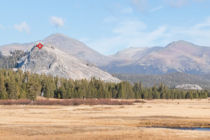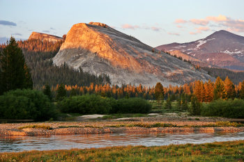
Lembert Dome
Distance: 2.8 miles (4.5 km) round trip
Elevation at trailhead: 8,500 feet (2,550 meters)
Elevation gain: 900 feet (275 meters)
Why climb Lembert Dome? Fancy a smashing new hat you saw in one of the Yosemite gift shops? Climb Lembert Dome in the afternoon and there's a good chance your dowdy old lid will get blown to somewhere near Mono Lake, giving you no choice but to buy a new one. If that's not attraction enough, Lembert Dome also offers excellent views looking west across Tuolumne Meadows.
Hiking Time: 1.5 - 3 hours
Difficulty: It's a short hike, but you are climbing a mountain, and you need to be careful to pick a safe route. A 4 out of 10.
Best Time to Visit: Pleasant anytime Tioga Road is open (June through October, usually), but best of all early, when the meadows are green.
Crowd Factor: Not bad; the dome is large and a bit awkward to reach, so the visitors aren't too many or too close together.
Parking: There's a parking lot at the trailhead, which is also the trailhead for the Dog Lake trail.
Food Storage Lockers: Just past the parking lot along the side road that starts where you turn into said parking lot; a few more another tenth of a mile down the road at the Glen Aulin trailhead, and more yet at the parking lot at the end of the road. If you take the longer route starting from near the Tuolumne Meadows Lodge, you should also find lockers in the day-use parking area there.
Nearest Restrooms: At the trailhead (outhouse variety); restrooms with running water available at the Tuolumne Meadows Visitor Information Center a mile or so to the west.
Nearest Snacks: A quarter mile (0.4 km) west of the trailhead
Getting There: From Yosemite Valley, take highway 120 ten miles (16.8 km) to the Crane Flat turnoff onto Tioga Road, then take Tioga Road 40 miles (64 km) east to reach the trailhead at the far eastern edge of Tuolumne Meadows. From Yosemite's east entrance at Tioga Pass, take the Tioga Road west 7 miles (11 km) to the trailhead. Here's a Google Street View Panorama of the turnoff to the parking area.
Already done this hike? Add a Review.
Lembert Dome Panoramas
From Virtual Yosemite