Taft Point and the Fissures
Distance: 2.2 miles (3.5 km) round trip
Elevation at trailhead: 7,700 feet (2,345 meters)
Taft Point Elevation: 7,500 feet (2,285 meters)
Elevation Change: 200 feet (60 meters) descent
Hiking Time: 1 - 2 hours
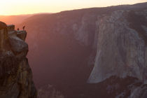
Why Hike to Taft Point? It's Glacier Point without the guardrails. Dramatic vistas of Yosemite Valley, especially El Capitan. Guaranteed to help you answer the question: Am I afraid of heights or not? And an excellent mildly sadistic people-watching spot, for seeing how your fellow hikers privately answer the same unsettling question.
Best Time to Visit: Whenever Glacier Point Road is open - roughly June through October
Crowd Factor: medium
Difficulty: Easy, though not a complete pushover. It's a fairly short hike without a lot of elevation change.
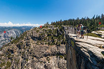
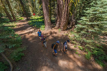
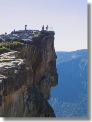
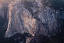
Scenery Summary: The trail to Taft Point is just another walk in the woods, but you'll never forget Taft Point itself. You can walk, if you dare, right up to the cliff's edge and peer straight down, unencumbered by the stone walls that hem the visitors in at Glacier Point. You'll get impressive views of the north valley wall, including El Capitan (which you'll actually be looking down on) and Yosemite Falls.
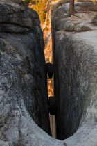
The Fissures - you'll be stepping around them on your approach to Taft Point - are also worth checking out. These immense vertical gashes in the valley wall were caused, it is now believed, by an epic battle between Mothra and Godzilla, during which Mothra slashed at his scaly foe but missed and raked his talons against the cliffside instead. (What, you didn't know that Mothra has talons? Check with your vet.)
Parking: At the trailhead, with an additional lot just to the west. The lots share the trailhead with Sentinel Dome and often fill up, so parked cars tend to fan out along the shoulders of Glacier Point Road, effectively adding another 16 miles of parking.
Nearest Bathrooms: Two pit toilets at the trailhead and two more in the overflow parking lot.
Nearest Snacks: Gift shop & cafeteria at Glacier Point, 7.5 miles (12 km) farther down the road (closes at 7 pm and closed all winter)
Food Storage Lockers: At the trailhead and in the overflow parking area.
Getting There: From the South entrance to Yosemite, turn left and travel 17.3 miles (28 km) to Glacier Point Road. From the valley, take road 41 nine miles (14.5 km) to the same road. Once you're on Glacier Point Road, follow it to the trailhead 13.6 miles (22 km) later. There's a small parking lot and outhouse on the left; here's a Google Street View panorama of the trailhead area. It's been revamped a bit since this street view was filmed, but should still be recognizable.
Hazards: The dropoff at Taft Point is steep, and a fall would be not just fatal, but squish-you-like-a-bug fatal. The fall is so far that your friends, waving their teary goodbyes and hoping you didn't have the only set of car keys, would lose sight of you before you reached the ground. So be careful.
Already done this hike? Add a Review.
Taft Point Photos
Taft Point Panoramas
From Virtual Yosemite