4-Mile Trail Map & Directions
Distance: 4.7 miles (7.5 km) one way; 9.4 miles (15 km) round trip
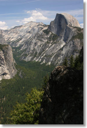
Yosemite Valley Elevation: 4,000 feet (1,200 meters)
Glacier Point Elevation: 7,200 feet (2,200 meters)
Total Elevation Change: 3,200 feet (975 meters)
Driving Directions: If you're parking at Glacier Point, you'll need to find Glacier Point Road and drive all the way to its end 16 miles (25 km) away at Glacier Point. The Glacier Point Road starts on Highway 41 at Chinquapin; it's 17 miles (28 km) north from the park's south entrance, or 9 miles (14.5 km) south from the spot where Highway 41 departs Yosemite Valley. (see a Yosemite map)
If you're parking in Yosemite Valley, you'll probably be parking at the trailhead, which is on Southside Drive just west of the Swinging Bridge, or near Yosemite Lodge (where the tour bus leaves from), on Northside Drive near Yosemite Falls.
Parking: There's a large lot at Glacier Point. If it's full, keep circling the lot, and something will probably open up soon.
In the valley, a dozen or so cars can fit at the trailhead. If it's full, you might be able to park at the Swinging Bridge parking lot, a few hundred meters farther east. If that's full, too (often the case), keep going and another hundred meters east, you'll reach the meadow opposite Yosemite Falls, which has about a quarter mile of parking along the left side.
If you haven't found a parking spot by now, try parking in the large day visitor lot near Yosemite Village or the large lot at Curry Village, then catching the free shuttle. The shuttle buses don't go all the way to the 4-Mile Trail's trailhead, but they'll get you in the neighborhood. You can get off the shuttle at the Yosemite Lodge and then hike to the trailhead via the trail to the Swinging Bridge, which will add an extra 0.75 miles (1 km) each way to your hike. If you're not sure you want to complicate things by finding the trail, get off the bus next to the Sentinel Bridge; from there, cross the bridge and turn west on Southside Drive (if you've gotten off at the right bridge, you'll see the Yosemite Chapel here), and you've got a mile (1.5 km) hike to the trailhead.
Here's a Google Street View panorama of the Glacier Point trailhead area; the 4-Mile trailhead will be on your left shortly past the gift shop. For bottom-to-top hikers, here's a panorama view of the hike's Yosemite Valley trailhead area, with Yosemite Falls visible off to the left.