351 miles (562 km) via east entrance *
447 miles (715 km) via south entrance
389 miles (626 km)
403 miles (648 km)
320 miles (515 km)
288 miles (463 km)
170 miles (273 km)
60 miles (96 km)
70 miles (112 km)
92 miles (147 km)
175 miles (281 km)
154 miles (247 km) *
205 miles (330 km)
226 miles (363 km)
342 miles (550 km)
306 miles (492 km)
182 miles (293 km)
173 miles (278 km)
174 miles (280 km)
196 miles (315 km)
Getting to Yosemite
There aren't any airports in or train routes to Yosemite, and cruise ships pull too much draft to navigate up the Merced River, so your trip to Yosemite is almost certain to involve a car or bus at some point.
If you don't live in the American west, you may want to fly to California and then rent a car. In addition to the major cities like San Francisco and Los Angeles, there are airports in several of the smaller Central Valley cities that lie closer to Yosemite.
The table below lists distances from a variety of airports to Yosemite; you're welcome to pick your favorite based on terminal decor, food court, or whatever else you prize most highly in an airport.
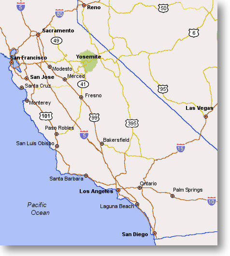
(If your eyes are too important to be bothered with scanning through tables, try dragging your mouse over the city names on the map instead; the little tooltips that pop up will tell you how far each city is from the nearest Yosemite entrance.)
| Airport Location | Via Entrance |
Distance to Yosemite Entrance Miles (KM) |
Distance to Yosemite Valley Miles (KM) |
|
|---|---|---|---|---|
| Bakersfield | South (41) | 170 (273) | 200 (321) | Directions |
| Boise | Tioga Pass (120) * | 576 (927) | 633 (1,019) | Directions |
| Burbank | South (41) | 271 (436) | 301 (484) | Directions |
| Denver | South (41) | 1,228 (1,976) | 1,258 (2,025) | Directions |
| Fresno | South (41) | 60 (96) | 90 (144) | Directions |
| Las Vegas | South (41) | 447 (715) | 477 (763) | Directions |
| Las Vegas | Tioga Pass (120) * | 351 (562) | 408 (653) | |
| Los Angeles | South (41) | 288 (463) | 318 (511) | Directions |
| Merced | El Portal (140) | 70 (112) | 78 (125) | Directions |
| Modesto | Big Oak Flat (120) | 92 (147) | 104 (166) | Directions |
| Monterey | El Portal (140) | 226 (363) | 256 (412) | Directions |
| Ontario | South (41) | 320 ((515) | 350 (563) | Directions |
| Palm Springs | South (41) | 389 (626) | 419 (674) | Directions |
| Phoenix | South (41) | 657 (1,057) | 687 (1,105) | Directions |
| Portland | Big Oak Flat (120) | 754 (1,213) | 766 (1,232) | Directions |
| Reno | Big Oak Flat (120) | 294 (473) | 306 (492) | Directions |
| Reno | Tioga Pass (120) * | 154 (247) | 211 (339) | Directions |
| Sacramento | Big Oak Flat (120) | 175 (281) | 187 (301) | Directions |
| Salt Lake City | Tioga Pass (120) * | 571 (919) | 628 (1,010) | Directions |
| San Diego | South (41) | 403 (648) | 433 (696) | Directions |
| San Francisco | Big Oak Flat (120) | 182 (293) | 194 (312) | Directions |
| San Jose | Big Oak Flat (120) | 174 (280) | 186 (299) | Directions |
| San Luis Obispo | South (41) | 205 (330) | 235 (378) | Directions |
| Seattle | Big Oak Flat (120) | 903 (1,453) | 915 (1,472) | Directions |
* Yosemite's eastern entrance, via Tioga Pass, is usually closed from November through May due to snow. See the Road Conditions page for the road's historical opening and closing dates.
And don't miss:
Alternatives to sleeping in your car
What's it gonna cost me?
Stuff worth seeing