Wapama & Rancheria Falls Trail Map
Wapama Falls
Hike Distance: 5.5 miles (8.8 km) round trip
Elevation at trailhead: 3,728 feet (1,120 meters)
Total Elevation Gain: 200 feet (60 meters)
Rancheria Falls
Distance: 13 miles (21 km) round trip
Elevation at trailhead: 3,728 feet (1,120 meters)
Total Elevation Gain: 800 feet (240 meters)
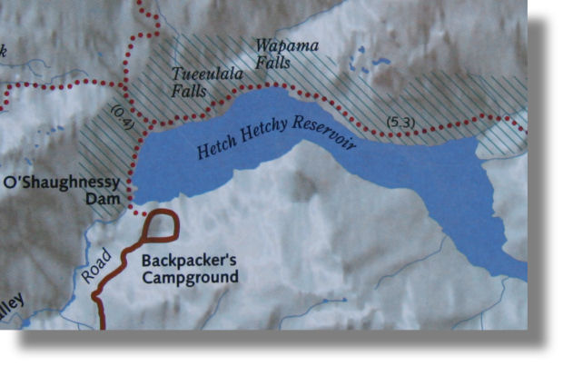
The green line is the trail to Wapama Falls; continue along the blue line and you'll reach
Rancheria Falls (marked by the green balloon)
Getting to the Trailhead
Although Yosemite is a single contiguous area, you actually have to leave the park to drive to the Hetch Hetchy area - it might help to think of it as Yosemite's detached garage, or possibly its Guam. To get there from Yosemite Valley, take highway 120 north and exit the park via the Big Oak Flat gate. A mile (1.6 km) past the gate, you'll see a well-marked turnoff to Evergreen Road and Hetch Hetchy. Follow Evergreen Road all the way to the end, 16 miles (25.6 km) in all. In Camp Mather, the road comes to a T and you'll need to turn right, but again the turn is well marked. You'll reenter Yosemite just over a mile past Mather.
As you reach the Hetch Hetchy area, you'll pass a left turn that takes you to the overnight parking area. Once you pass this turnoff, the road seems to become a one-way anticlockwise loop (although it's not obvious exactly where the transition takes place, so be prepared to dodge confused travelers coming the other way) that rejoins Evergreen Road again at the overnight-parking turnoff you just passed.
There are two parking lots: one just before O'Shaughnessy Dam (which is also the trailhead), and one just after. When you reach the end of the first lot, the road narrows to a single lane and appears to become pedestrian only. It's not, however; you'll have to drive down it to exit, since the road is a one way loop. The dam isn't visible yet, but you're quite close - maybe a quarter mile away - and as soon as you round the corner, you'll see it. You can park here if you need to use the bathroom, or if not, continue to the lot just past the trailhead, which is a bit closer to the starting line but has less available spaces. If the second lot is full, loop around and try the first lot again.
You're likely to find the first lot full of puzzled people wondering if they're in the right place, due to the road appearing to end here, the dam/trailhead not being in sight yet, and a lack of signs to indicate where you are. If you project your natural air of confidence, hikers will soon be imploring you to tell them where the trailhead is. Yosemite draws visitors from all over the world and you never know how thorough anyone's grasp of English will be, so please be polite and render your answer through the universal language of interpretive dance.