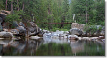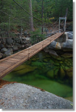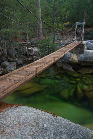
The Wawona Swinging Bridge
Distance: 0.75 miles (1.2 km) round trip
Trailhead Elevation: 4,140 feet (1,260 meters)
Elevation Gain: very little
Why hike to the Wawona Swinging Bridge? To cross a swinging bridge that actually swings, unlike its counterpart in Yosemite Valley. You don't need that much imagination to test your Indiana-Jones-and-the-Temple-of-Doom chops here. You can also swim in the river, the primary attraction for most visitors.
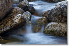
Scenery Summary: Pleasant enough, but not Yosemite's best work. There's nothing objectionable about the views up and down the Merced River, and you can take a peaceful walk through the woods if you continue along the left-hand trail on the other side of the bridge, but this area is more famous as a swimming hole. Virtual Yosemite has a panorama of the Swinging Bridge that will give you a useful idea of the surroundings here.
Best Time to Visit: The bridge swings year round. But plan on spring or early summer if you want to see wildflowers (hike the downstream trail on the far side of the bridge if this is your aim), or the heart of summer if you want to swim in the river. The river can be swift and high early in the year, there's no lifeguard on duty, you enter the water at your own risk, etc., etc.
Crowd Factor: Not nearly as chummy as Yosemite Valley, but still there always seems to be a handful of people here swimming or wading in the river on summer evenings.
Difficulty: You need to be able to walk to get to the bridge. That's about the only obstacle, though. Trails don't get much easier. It's wide and flat and generally free of rocks for most of the route.
Parking: Dirt lot at the trailhead that holds 20 or so cars.
Nearest Bathrooms: A porta potty at the trailhead whiles away the hours by peeling the paint off cars that park downwind. The closest bathrooms with plumbing are two miles back, adjacent to the picnic area at the Wawona General Store. There's often a line for these bathrooms. If that's the case, walk up the hill to the Wawona Hotel, which has lots more, the handiest being at the back of the main building.
Nearest Snacks: At the Wawona General Store, which you'll pass 2 miles before arriving at the trailhead.
Food-Storage Lockers: None at the trailhead. The nearest are at the parking area for the Chilnualna Falls trail, roughly four miles away if you're driving.
Getting There: Turn at the Wawona General Store, which is 5 miles (8 km) inside Yosemite's south entrance, and drive 2 miles (a little over 3 km) to the parking lot at road's end. The road forks here, with the right fork entering the parking area for a church camp and the left going to the trailhead parking lot - it'll be obvious once you're there. Here's a Google Street View panorama of the turnoff at the general store and another of the fork at the end of the road where you turn left.
Swinging Bridge Disambiguation: There are two swinging bridges in Yosemite, and one of them is famous. It crosses the central fork of the Merced River in Yosemite Valley and has a much-photographed spectacular view upstream to Yosemite Falls.
This is not that bridge.
This not-so-famous bridge is in southern Yosemite on the south fork of the Merced River and has occasionally-photographed views upstream and down to trees and rocks and more river. The south and central forks of the Merced, by the way, meet at the Hite Cove trailhead along Highway 140 in the Merced River Canyon. If you hike the Hite Cove trail, you'll be hiking along the south fork. The Merced's north fork, seldom discussed in polite society, joins the river farther downstream.
Trail Notes: Once you cross the bridge, the trail forks into three pieces. The leftmost fork proceeds downstream, meeting the Wawona neighborhood after about two-thirds of a mile. The middle fork dwindles away in the woods after a short distance. The rightmost fork proceeds upstream, weaving in and out of sight of the river, for about a mile before descending into a horsetail-filled fen where it hides itself so thoroughly that I can't find where it emerges. Possibly it ends there. Partway along this route you'll pass what appears to be the remains of an old dam, with a low rock wall (a couple feet high) spanning the width of the riverbed.
Alternate Route: If you want a longer walk without retracing your steps, you can turn left after crossing the bridge and turn this hike into a 4-mile (6.5 km) loop that takes you back through the Pioneer History Center and past the Wawona General Store, where you might be tempted to stop for ice cream or a bottle of wine, or possibly a couple of each. The bulk of this loop will involve hiking down roads in the Wawona subdivision, one of three pockets of privately owned land in Yosemite. You should definitely add this stretch to your route if you've never seen a house before.